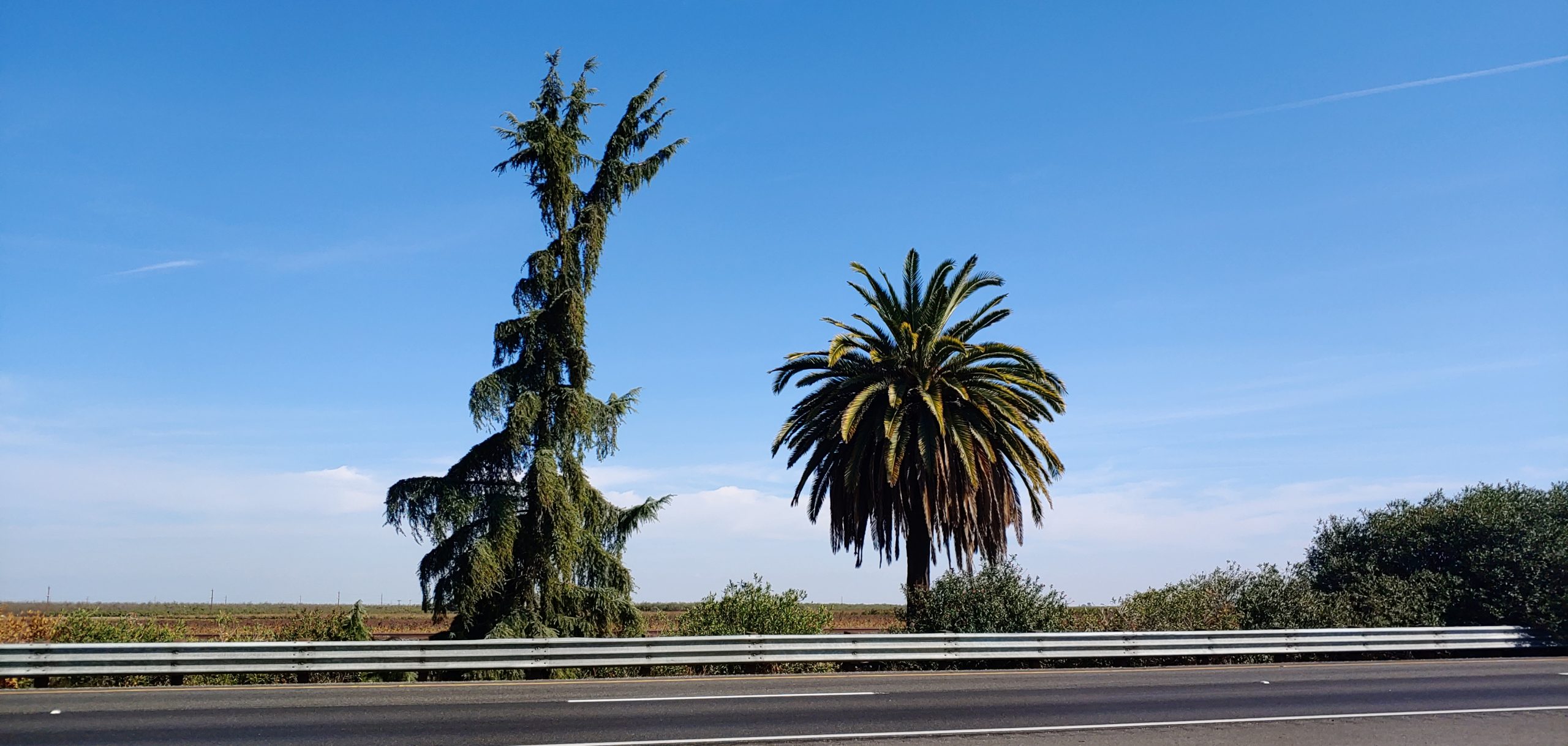
Just south of Madera, 1.75 miles south of Ave 12, and 2.1 miles north of Ave 9 (or more specifically at 06-MAD-99-05.7), there lies a pine tree and a palm tree in the median of Highway 99. It has been there since the 1920’s and marks the former halfway point in California. The Palm Tree, a Canary Island Date Palm, represents Southern California and the Pine Tree, a Deodor Cedar, represents Northern California. In 2005, the pine tree fell down but was replaced by Caltrans in 2007 as this is a somewhat historic marker. In the next couple of years, Caltrans District 6 intends to remove the Pine and Palm for a highway widening project. New trees are planned to the west of the current site but no marker at this time. For more information about this Caltrans project, please go to the link below:
We, the Historic Highway 99 Association of California, intend to have signs placed in both directions at this location to mark the historic site. While it might not exactly be the “halfway” point in California, it is close enough and has been there since the 1920’s. We are looking to work with local agencies such as the County of Madera, Caltrans District 6, City of Madera, and others to gain support and assistance with this effort. We already have a tentative design for the sign and cost estimates for its fabrication.
If you would like to be involved in this project (03-MAD21002), let us know! We can use help either through donations of labor or money. Any donations are likely tax-deductible as we are a 501c3 organization.
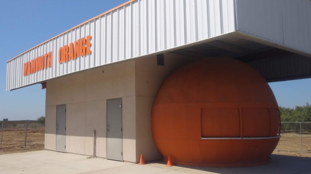
For Immediate Release Media Contact: Kate Holden Director of Public Relations 559-683-4636 kate@yosemitethisyear.com Mammoth Orange to Squeeze Back into the Spotlight at the Fossil Discovery Center of Madera County The historic structure was restored to its former glory thanks to the generous donation of time and materials by the Rotary clubs of Chowchilla, Madera and Madera Sunrise.
MADERA COUNTY, CA – September 8, 2023 – Many long-time residents of California’s Central Valley will remember The Mammoth Orange as a local landmark. The Mammoth Orange was a refreshment stand located on Highway 99 and was known for its giant hamburgers, excellent fries, and out-of-this-world orange shakes.
This historic building is set to make a juicy comeback on Saturday, September 23, 2023, at 6:00 PM, when the Fossil Discovery Center of Madera County invites the public to celebrate a piece of local history with a fundraising dinner and ribbon-cutting ceremony.
The original Mammoth Orange closed in 2007 and was abandoned in a storage yard. Later, the 20-foot orange was brought to the Fossil Discovery Center and painstakingly revived. The structure was carefully restored to its former glory as a concession stand and a San Joaquin Valley attraction, thanks to the generous donation of time and materials by the Rotary clubs of Chowchilla, Madera, and Madera Sunrise.
“We are thrilled to be reopening the Mammoth Orange at the Fossil Discovery Center,” said Michele Pecina, Director of the Fossil Discovery Center. “This iconic landmark is a believed part of our community, and we are excited to share it with a new generation of visitors. The Mammoth Orange is a great example of how history creates unique and memorable experiences.”
The Fossil Discovery Center of Madera County is a museum that houses a collection of fossils, including ancient Columbian Mammoths. It sits adjacent to one of North America’s most extensive middle-Pleistocene fossil excavations, where discoveries continue to this day. The museum offers a variety of educational programs and activities for visitors of all ages.
“The Mammoth Orange is a great addition to the Fossil Discovery Center,’ said Pecina. “It will help us attract more visitors to the museum and learn about our region’s rich history.”
Tickets for the ribbon-cutting event are $25 for members of the Fossil Discovery Center and $30 for non-members. Tickets include a Smashburger meal served from the Mammoth Orange.
The Mammoth Orange ribbon-cutting ceremony is an excellent opportunity to celebrate local and ancient history.
Come one, come all to the Fossil Discovery Center of Madera County on Saturday, September 23, 2023, at 6:00 PM. For more information and to purchase tickets, please visit www.maderamammoths.org or call (559) 665-7071.
About Visit Yosemite | Madera County Formed in 1985, Visit Yosemite | Madera County’s mission is to draw the millions of Yosemite National Park visitors to its gateway’s many businesses and attractions. We invite visitors to take a journey from the Fossil Discovery Center to the Madera Wine Trail and onward to the High Sierra. Discover incredible dining, talented tradespersons, four seasons of water sports at Bass Lake, the Yosemite Mountain Sugar Pine Railroad and mighty adventures right up to the massive Giant Sequoia trees. Madera County is the gateway to so much more.
Yosemite Sierra Visitors Bureau | 40343 Highway 41, Oakhurst, CA 93644
A Brief History of Grapevine Canyon in Kern County and US Highway 99 – Part 1 by Michael F Ballard
1914 – 1933
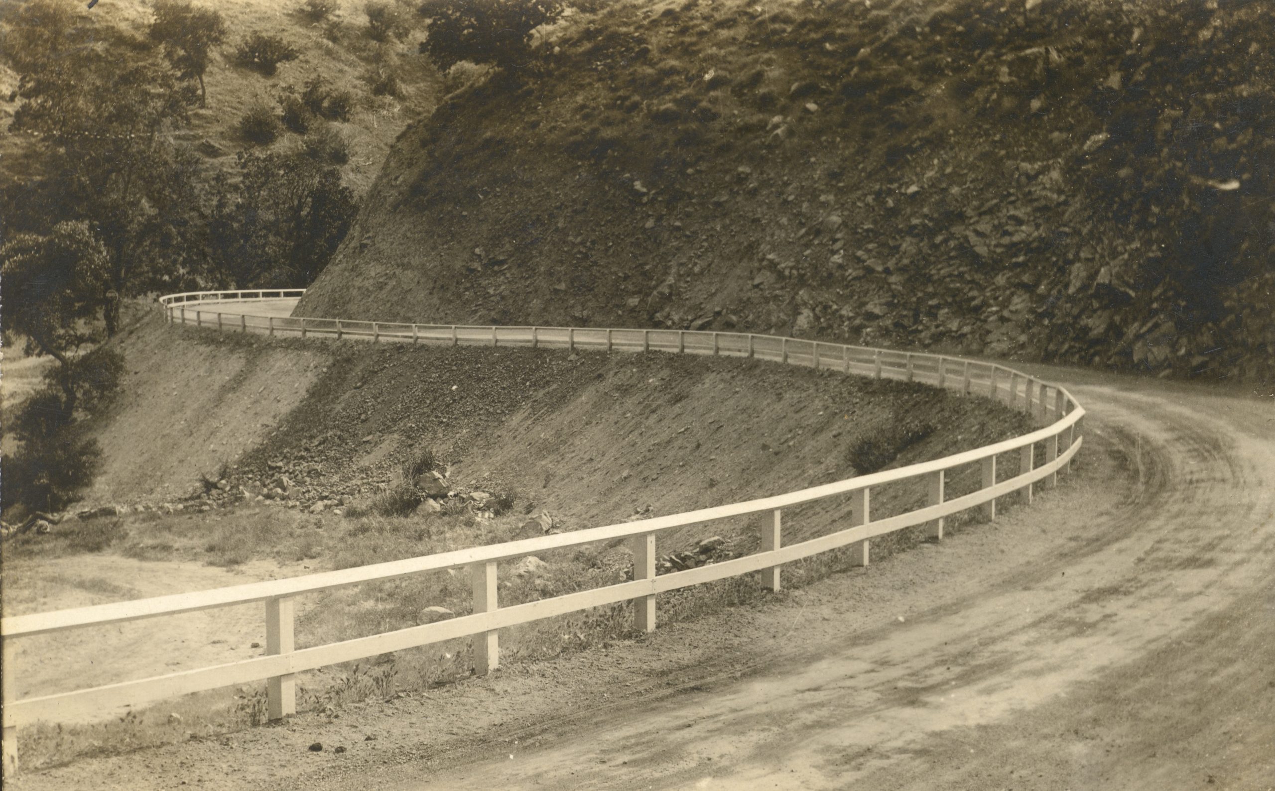
Dead Man’s Curve in 1914, just after construction
Grapevine Canyon, or Canada De Las Uvas, was named for the wild grapes that grow on its slopes by Spaniards in the 1700′s. The town of Grapevine has been a major stop along this highway ever since the Ridge Route was built in 1914. This first alignment was one of the most torturous sections of US 99 in Southern California. It had more than a few very sharp curves, some of which ended up with names such as “The Loop” and “Deadman’s Curve”. Both of those curves still exist today, though partially removed and cutoff from the new roadways. In 1915, the grade was oiled creating a more solid, albeit temporary, roadway. Grapevine Grade received its first concrete pavement in 1919, a “full” 20 foot slab with curbing and little in the way of a shoulder. The original location of the “town” of Grapevine was at the bottom of the grade. It consisted of a motel, store, gas station, and restaurant. In 1926, work commenced to “daylight” some of the sharper curves along the grade, which increased sight-distance and did help to reduce collisions. It didn’t, however, reduce the curvature of the road.
1933 – 1943
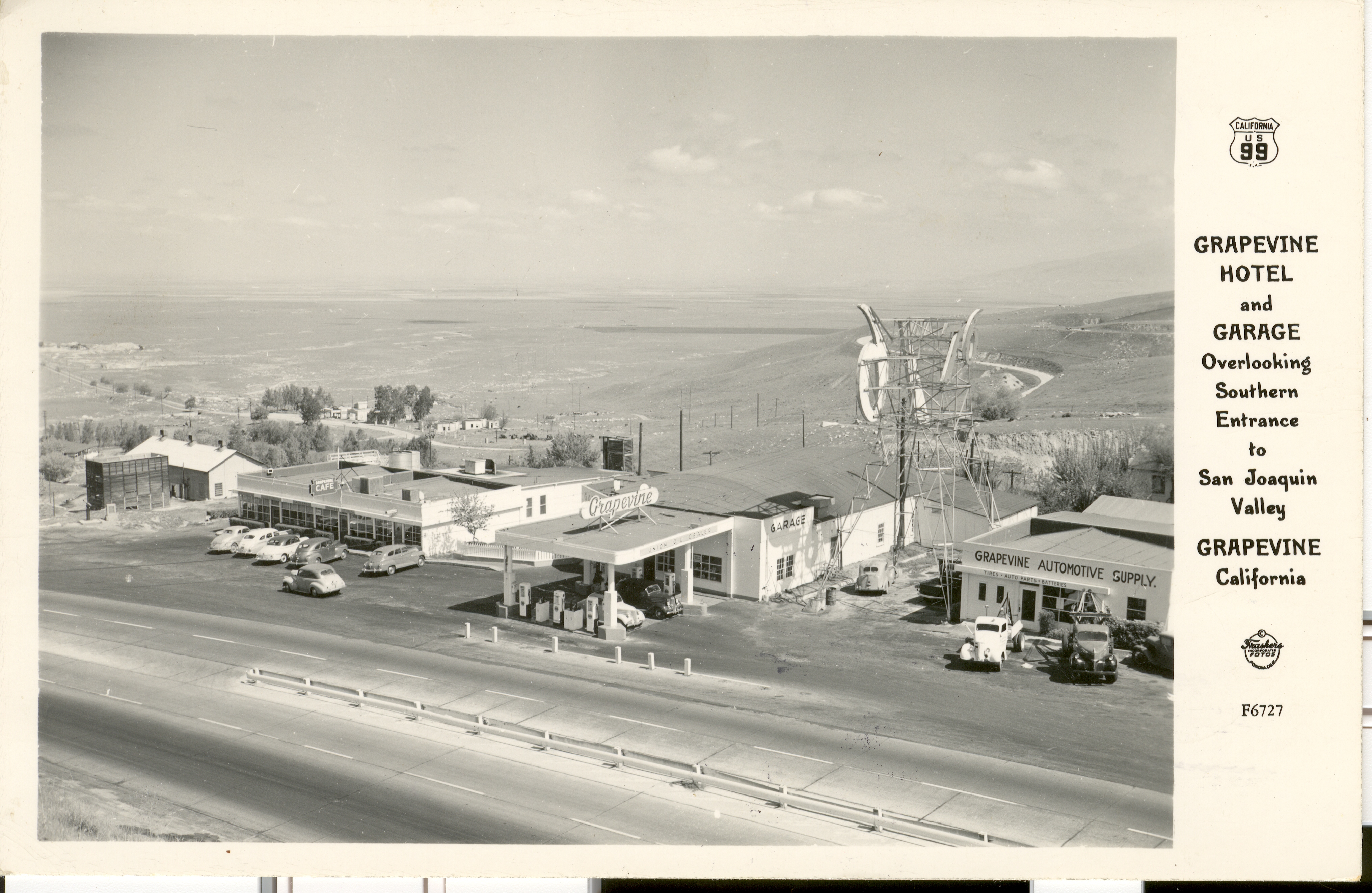
Postcard showing the Grapevine Cafe and gas station
In 1933, a new alignment of US 99 was built. It ran along the current southbound lanes of I-5 for most of the grade. Deadman’s Curve and the Loop were eliminated at that time. When the concrete was first poured, only two lanes were built. About a year later, the third lane was added making the center lane the passing lane. Since the original location of Grapevine was bypassed, it was partially relocated onto the new grade, this time in the canyon. While it was rather conveniently located, it did suffer from one fatal flaw. It was near the bottom of a very long, steep grade, and on the outside of a curve. As a result, runaway trucks smashed through on a few occasions.
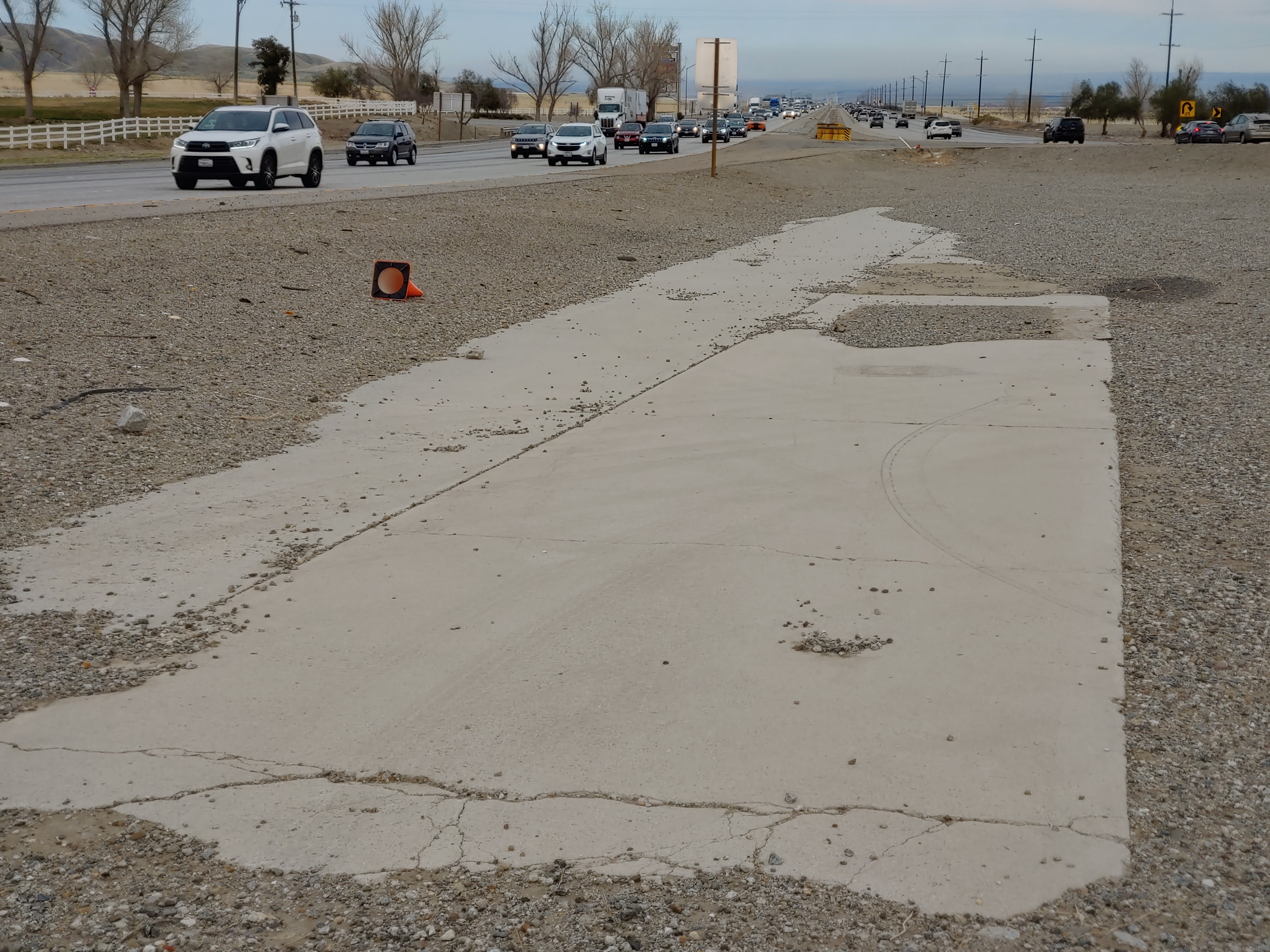
1932 / 1933 concrete in the median of I-5 at Grapevine. Courtesy Michael F Ballard
Shown above, a small section of concrete is visible adjacent to the southbound lanes of I-5. A small color difference can be noticed between the two lanes that are visible. This difference is due to age. The lanes to the left were constructed in 1932 when Grapevine Grade was realigned, bypassing the original 1914 Ridge Route grade. This was built as two lanes as a temporary measure to expedite the opening of the new route. Right after it was opened, a third lane was added, the lane on the right, creating a three-lane roadway with a common passing lane in the center, or “suicide lane”. This condition persisted until 1943 when the road was widened yet again to four lanes. In 1958 – 1960, these lanes were bypassed by the current southbound lanes of I-5. Today, they remain as one of the last remnants of the 1932-1958 version of Grapevine Grade.
To be continued in our May / June 2022 Newsletter
March 2022 Presentation
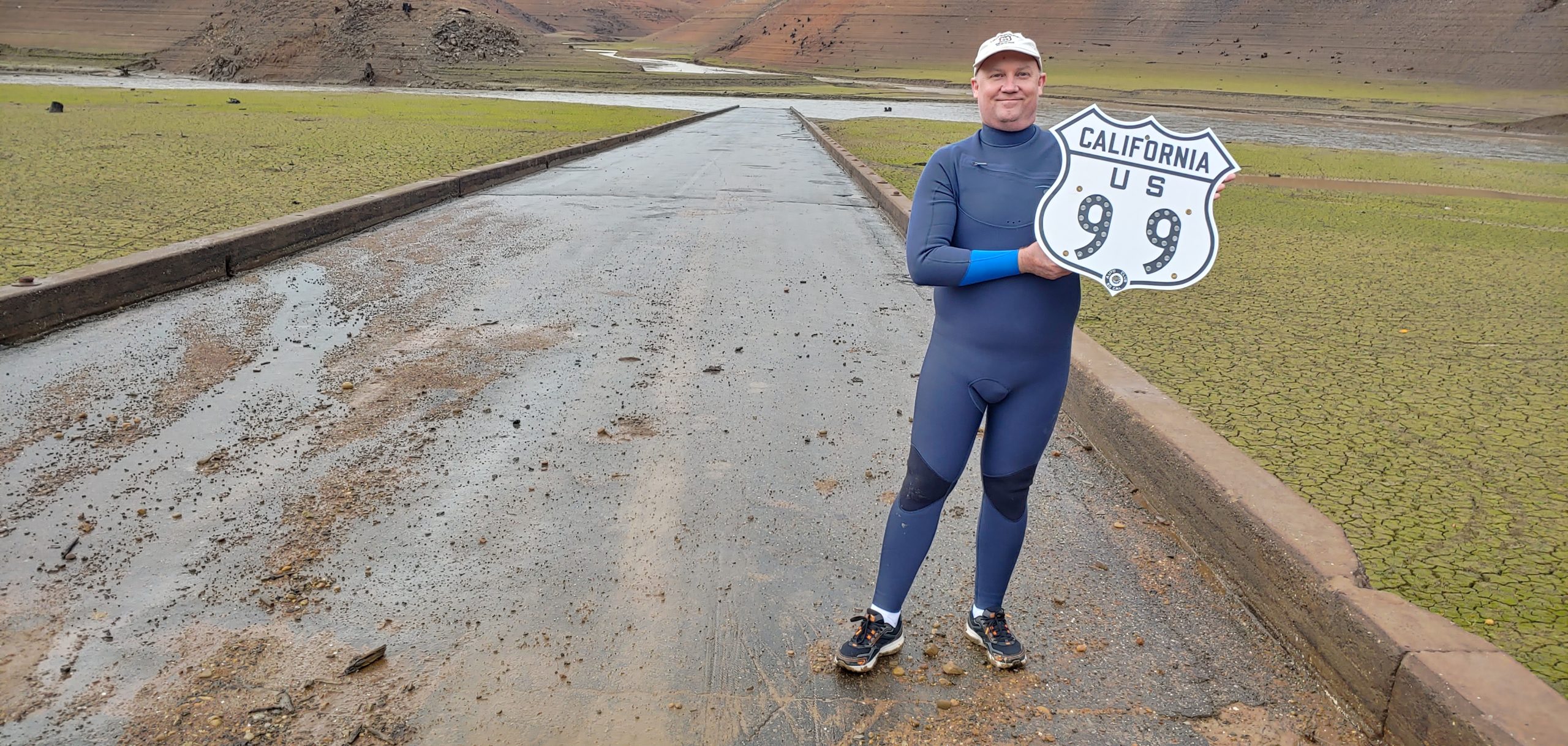
At the Pollock Bridge in November 2021, then fully exposed. Courtesy – Michael F Ballard
Join us on Tuesday, March 8, at 6pm for a presentation on Lake Shasta and Environs by Michael Ballard. We will be sharing photographs from our November 2021 trip to the Lake Shasta area showing the low lake level as well as some additional photos of the surrounding area.
Please register for the presentation using the link below:
Just south of Madera, 1.75 miles south of Ave 12, and 2.1 miles north of Ave 9 (or more specifically at 06-MAD-99-05.7), there lies a pine tree and a palm tree in the median of Highway 99. It has been there since the 1920’s and marks the former halfway point in California. The Palm Tree, a Canary Island Date Palm, represents Southern California and the Pine Tree, a Deodor Cedar, represents Northern California. In 2005, the pine tree fell down but was replaced by Caltrans in 2007 as this is a somewhat historic marker.
We, the Historic Highway 99 Association of California, intend to have signs placed in both directions at this location to mark the historic site. While it might not exactly be the “halfway” point in California, it is close enough and has been there since the 1920’s. We are looking to work with local agencies such as the County of Madera, Caltrans District 6, City of Madera, and others to gain support and assistance with this effort. We already have a design for the sign and cost estimates for its fabrication.
If you would like to be involved in this project (03-MAD21002), let us know! We can use help either through donations of labor or money. Any donations are likely tax-deductible as we are a 501c3 organization.
99 Alert – William S Hart Park in Santa Clarita
One of our members and local historians, Evan Decker of Santa Clarita, has brought to our attention something concerning a park in his area. William S Hart Park, the former home of the silent film actor, is currently a park owned and administered by Los Angeles County. This arrangement is due to the stipulations in the will of William S Hart, who deeded the land and associated structures in perpetuity to Los Angeles County.
The City of Santa Clarita, in an effort spearheaded by the current major Laureen Weste is looking to take over the park. By itself, it would seem like a “home rule” sort of issue, which can be a good thing. However, the City of Santa Clarita has a poor track record of preserving history and keeping it safe. This has been shown with the “disneyfication” of the central business district of Newhall, among other things. We feel this change would be a detriment to the historical value of Hart Park and would not be to its best interest.
If you would like to help with preventing the City of Santa Clarita from taking over William S Hart Park, Even Decker has set up an online petition to sign. He also strongly recommends contacting the office of Los Angeles County Supervisor Kathryn Barger and tell her you’re against this project.
We, the Historic Highway 99 Association of California, only want to help preserve and protect the history along Highway 99. Newhall was one of the towns along the earliest alignment of US 99. Hart Park represents a part of that early history.
Please sign the petition created by Evan Decker to tell the City of Santa Clarita that you want the park kept as-is and not in City hands.
Membership and Donations
As we slowly ramp up our efforts to get Historic Route signage placed in various cities and historic locations such as the Pine and Palm, we need your support. You can do this by becoming a member, donating money, or by volunteering with our Association. We are a 501(c)3 non-profit corporation and your donations may be tax deductible. Why not help reduce your tax burden for 2023 by donating prior? We can also use your help with some of our projects, website, and our newsletter. Having someone local to act as our ambassador or liaison would be of great help. We are also working out how to handle renewals for existing members. Initially, we had planned to have all memberships expire at a specific time. At this time, we are looking to have memberships expire at the end of the month initially obtained. We will be sending out a letter to our current members to explain how to renew. Join now and help us grow!
We do wish to thank all those that have donated and become members thus far. Our most recent project in Madera couldn’t have happened without your support!
Featured Photo
Hawkbryn Ave in Newhall, CA. Courtesy – Michael F Ballard
Recently, a section of 1930 US 99 was rediscovered in the Santa Clarita Valley. Thought lost since the 1960’s, a small section of the 1930 “Newhall Alternate” was found along a residential street south of Lyons Avenue. This roadway, at least a portion of it, represents one of the few remaining sections of the 1930 roadway north of Calgrove Blvd. In 1967, I-5 was constructed here and the new road was shifted a little to the west, leaving this road, now known as Hawkbryn Ave, as a frontage road. Traces of the 1930’s concrete can still be detected today. This section was discovered using comparisons between aerial photography and the construction plans from 1949 and 1967.
Despite having traversed this area many times, I never thought to look here. Always keep your eyes open, for you never know what you might find.
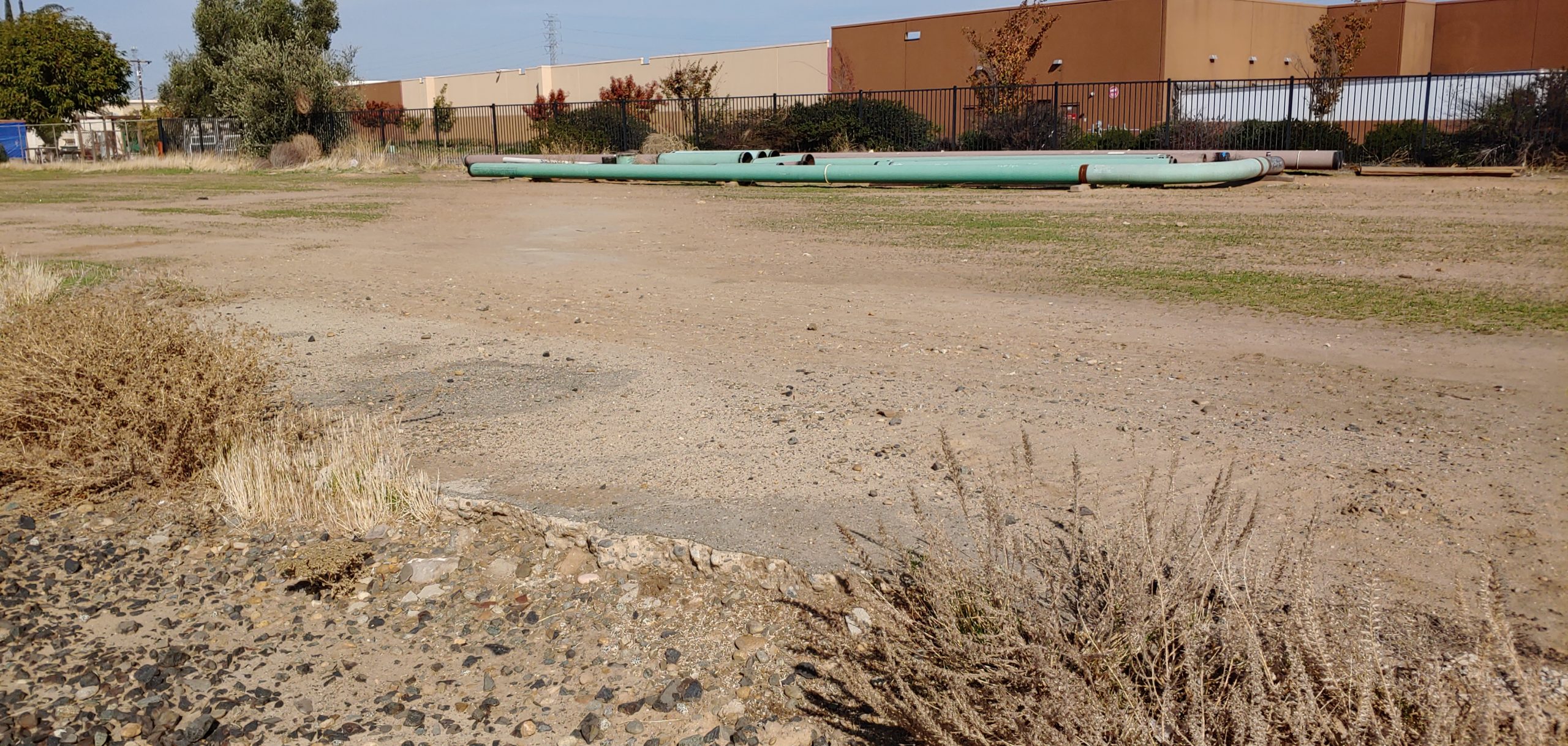
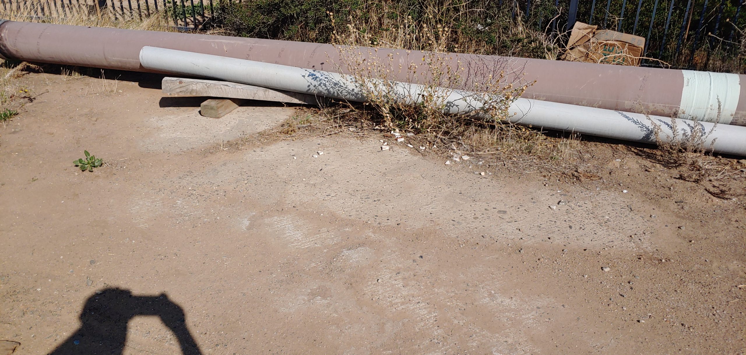
Back in July, we had a request for a photo of a section of roadway near Herndon, CA. In early November, I finally got a chance to get up there myself and investigate what looked like original paving. Turns out, I was correct!
Looking northerly from the railroad tracks. Note the thin section of concrete and asphalt covering.
Exposed concrete near the fence.
Mostly covered in dirt, the pavement isn’t very visible except for the lack of plant life along its path.
Since being bypassed in 1927, this roadway has gone through a lot. The railroad line has been upgraded, buildings constructed, fences installed, and more. Despite all that, it persists to this day. However, the paving may not last for very longer. Construction of the CAHSRA and the relocation of Golden State Blvd will likely remove any trace of this paving in the next couple of years. Sections like this are getting rare and need to be preserved in some way, even if only in photos. Use every opportunity you can to get out there and explore Historic US 99. Document what you find. You never know if that may be the last time you see it.
If you have a photo of a section of US 99 that you’d like to share or would like to know more about, let us know!
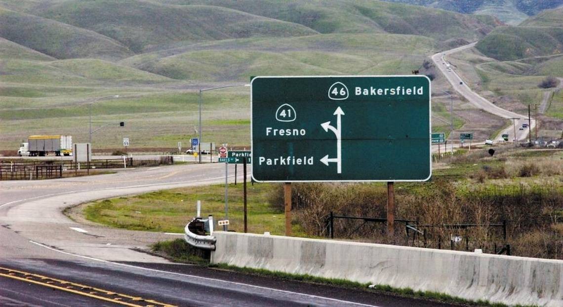
Contemporary photo shows Route 46 & abandoned Route 466 to the right of pic.
Sandy and I live eight miles East of Auburn in Cool, California. We enjoy vacationing every year at Avila Beach. Driving the roads to picturesque Avila Beach is where this story begins.
From Cool we travel South on I-5 and turn off at State Route 41 and cross over onto Route 46 west at the junction; and then onto the 101 south toward Avila Beach. The junction of Routes 41 and 46 are in the middle of nowhere, at the end of a long drive; and even though I had seen the sign marking the “James Dean Memorial Junction” more than once—what I was reading didn’t register with me for two or three years. Finally, I had to ask: “Was this lonely Y Junction, located in a cow pasture among the parched & rolling foothills of San Luis Obispo County, the place where the world-famous actor was killed in a nearly head-on collision?” It didn’t seem possible to me. I began looking closely into this accident and James Dean’s short life. It became an ever-expanding whirlpool of persons / time / places and happenstance. And, oh yes, it’s a tale of some very bad driving.
James Dean’s last picture was “Giant” staring Rock Hudson and Elizabeth Taylor. James Dean had a supporting role in that movie.
Elizabeth Taylor’s number 4 husband was Eddie Fisher. In his autobiography, Eddie, wrote this about Elizabeth after their 1964 divorce: “Ah, Elizabeth Taylor! She is every man’s dream, the most beautiful woman in the world… with the morals of a truck driver!”
About two weeks after Dean competed filming his part in “Giant” he was off to the races.
Dean had a reputation of taking a lot of unnecessary risks when driving hot cars or motorcycles on public roads. More recently he had taken up car racing in the Southern California area. On September 30, 1955, Dean and his Mechanic Rolf Wütherich were on their way to enter Dean’s brand-new “Little Bastard” Porsche in an SCCA Club race being held at the Salinas Airport. There were two options when it came to getting the Spyder to the race track: Dean could’ve used his personal tow vehicle and a trailer he borrowed to haul his car, which was the original plan. Or he could’ve driven his Spyder on the streets, in traffic, over the long drive to the track. He chose the latter, which was not unusual for the competitors in this race to do. However, in his memoir, “Jimmy & Me”, friend and follow race car driver, Lew Bracker, wrote that he would never have let Dean drive that car to the track if he had known about it before hand.
In 1955 there was no Interstate-5, rather, there was HWY 99 running North and South along a somewhat similar alinement. Also, there was no State Route 46 as of yet. The road being used at that time was Route 466.
James Dean and his mechanic Rolf Wütherich drove north from the Sherman Oaks area to join HWY 99. Later, he drove over the four-lane Ridge Route Alternate [HWY 99]. When he made a short stop at Blackwell’s Corner, he bragged to fellow racecar driver, Bruce Kessler, that he had driven his Porsche Spyder 550 at one hundred and twenty mph over a section of HWY 99. Most likely a downhill section in the Wheeler Ridge area.
Rolf Wütherich was a German national who was employed in the Porsche Factory”s racing department. During World War II, he served in the Luftwaffe as a teenaged glider pilot; paratrooper and aircraft mechanic. His time in the Luftwaffe instilled in him the lifetime love of high performance machinery on which he later became an expert. It is rumored that taking on the more mature Wütherich as Dean’s ‘race team’ was part of a deal in getting the owner of Competition Motors, Johnny von Newman, to agree to sell the Spyder to James Dean in the first place. Von Newman definitely didn’t think that Dean had enough racing experience to handle the latest and more powerful model. Dean already owned a Porsche Super-Speedster 356, which was considered more of an entry level racer as compared to the Spyder 550.
The fatal wreck occurred at the junction of State 41 and US 466, near the town of Cholame, California, when a Cal Poly student, who was headed east on 466, made a left-hand turn at Route 41 in front of Dean’s oncoming Spyder, which was heading west on 466. Both drivers were exceeding the posted speed limit, however, I’ve been over both Routes 46 and 41(not to mention over the remains of old 466) and nobody drives at the posted speed limit in that area—including myself—and I don’t think anybody ever has. Just how fast Dean was driving is a subject of considerable controversy to this day. The controversy started with the two original investigating CHP officers who couldn’t agree on which party was to blame or how fast the drivers were traveling. During the wreck, Rolf was thrown clear of the Spyder and survived, but spent a year in the hospital and likely had some very ugly and permanent personality changes that got him into serious trouble.
As for myself, I’ve hiked over all the remaining sections of old Route 466 in the Polonio grade area of Antelope Road [CA 46] in both directions a number of times. There are three distinct remaining sections—Starting at the Antelope Exit near a place called Poison Water Pond that can be seen on Google Earth, you can walk west unimpeded all the way to the Memorial Junction. Also you can walk east from the same starting point [Antelope Exit] to where old 466 has been buried under the modern Route 46. You’ll have to climb over one barbed wire fence in the small parking area to get onto this section. There is another short section on the North side of 46, which actually is a continuation of old 466 as it comes out from under the 46 roadbed mentioned above. This last section is accessed from 46 westbound and is just across 46 from the Polonio Pass Pumping Section. The entire 466 remains total about seven miles in one direction give-or-take. Old 466 throughout the Polonio Pass area looks more like the 1915 era Ridge Route through the Tehachapi Mountains than it does the modern California, State Route 46.
I’ve heard that some people have driven motorcycles over some or all of historic 466. I think you would need an ATV to drive over all of 466 in a four wheel vehicle. Personally, I wouldn’t take a motor vehicle up there because it damages the exposed road surfaces and increases your chance of being spotted. Keep in mind that all of the remaining sections are on 100% private property. Standing out might get you stopped. Also, I would never take a pet dog with me to 466 because it’s a cattle ranch, and ranchers have the legal right to shoot any dog that they even think is worrying their cattle and / or you might get a visit from the CHP. However, I think the odds of any of that happening to you are pretty low. Plan your visit to the James Dean Memorial Junction area in the spring time to see the beauty of the green hills and flowers in bloom.
There are a number of interesting side trips to take regarding James Dean history in the Junction area. Blackwell’s Corner has been on 46 since before there was a 46 and long before Dean stopped there on his last ride. In fact, it was the last controlled stop he ever made. Blackwell’s has a small James Dean museum in the far corner of the shop, which includes Dean’s driving goggles picked up on 466 immediately after the accident (one rumor has it that these googles were actually being worn by Rolf on that day). Blackwell’s Corner Store is a great place to shop for olives; pickles and many other delicacies. It’s a must stop for Dean Fans. How James Dean got to the Blackwell’s Corner area, and beyond, is also a subject of controversy. He either drove north on HWY 99 toward Famoso, the city lost in time, and then turned directly onto 466 westbound, or he took, the so-called “Racers Road”, which starts at the HWY 99 cutoff onto 33/166 toward Maricopa and the town of Taft et cetera. The oil derricks along the Racer’s Road are reminiscent of scenes out of the movie “Giant”. Both these routes go by Blackwell’s Corner. I’ve driven over these two routes in both directions a number of times as well. Frankly most of this countryside is ‘lost in time’. Many places look as if they haven’t changed since 1955. I like driving through this general area—it’s an instant ‘History Rush’, for me.
I would like to give a shout out to some of the people I’ve asked questions of over several years regarding James Dean and his final ride.
Shannon Wafford, who fact-checked this article and made helpful suggestions, has hosted the annual James Dean Memorial run for the last six years; and has learned a great deal of insider’s information & made many invaluable contacts along the way. This run starts in Hollywood and ends in Salinas (you can pick it up on any part of the route with previous arrangement with Shan). Shan is a film maker and custom car builder with some 30 years of experience. He knows how cars perform on the race track. http://www.facebook.com/jamesdeanslastdrive
Michael Ballard who encouraged me to write this article. He has an encyclopedic knowledge of all the SoCal highways and byways; and their histories. He must have an amazing photographic memory:
Harrison Irving Scott who was very personally moved when he first heard that James Dean had been killed when it occurred back in 1955. Scottie is the very embodiment of the Ridge Route’s history today. He has written two books regarding the Ridge Route and a number of articles and has given many interviews. He was the subject of Huell Howser’s “Road Trip America” the “Ridge Route-2003 Season 1 Episode 22”: http://www.ridgeroute.com/
Lee Raskin took the time to answer my many questions regarding James Dean early on. He is the author of excellent books on this and related subjects, including “James Dean on the Road to Salinas” 2015 :
I’ll attempt to answer questions you may have… as others have answered my questions:
manxcat2@sbcglobal.net
December Presentation
Join us on December 7th, 2021 for a presentation on the Historic Ukiah-Tahoe Highway Association by Mike Herman. He will discuss the Historic Ukiah-Tahoe Highway Association and a Travel Guide that he wrote about Historic US 99W in California, “The Forgotten Highway”. At this meeting, we will cover some of the ups and downs of trying to get the Association started. We will also discuss how this turned into writing several Travel Guides including the one about US 99W. We hope that you can attend the Zoom Meeting on Dec. 7th at 6pm.
We restarted our online discussion forums for Historic Highway 99. Come join in! Tell your Highway 99 stories, discuss your favorite place along the road, learn about the history, and more!
Things are looking up! We have a few projects in the works at various levels now. In Madera County, we are working on posting signs to mark the Pine and the Palm along Highway 99. At this time, we are in the design phase for the signs. We are also looking into getting it designated a “Historic Landmark”, which is something we will need help with. We intend to work with local historical societies, Madera County, and Caltrans to get this done.
We will also be working with Caltrans District 2 to have Historic Route signs posted along State Highway 263 between Yreka and Hornbrook along the Historic Shasta River Canyon alignment. After surveying the route, we have determined that six signs should be posted. These signs would be posted at the 3/263 junction, 1931 Pioneer Bridge, and at the 96/263 junction.
If you have an idea for a project for the 99 Association or would like to get involved, let us know!
Board Position Open
We are currently seeking a Treasurer for our organization to manage our finances and be a part of the decision-making process. If you are interested, or know someone that might be, contact us. We’d love to have you as a part of our team and help keep Historic US 99 alive in California!
Membership and Donations
As we slowly ramp up our efforts to get Historic Route signage placed in various cities and historic locations such as the Pine and Palm, we need your support. You can do this by becoming a member, donating money, or by volunteering with our Association. We are a 501(c)3 non-profit corporation and your donations may be tax deductible. Why not help reduce your tax burden for 2022 by donating prior to the new year? We can also use your help with some of our projects, website, and our newsletter. Having someone local to act as our ambassador or liaison would be of great help.
We do wish to thank all those that have donated and become members thus far. Our most recent project in Madera couldn’t have happened without your support!
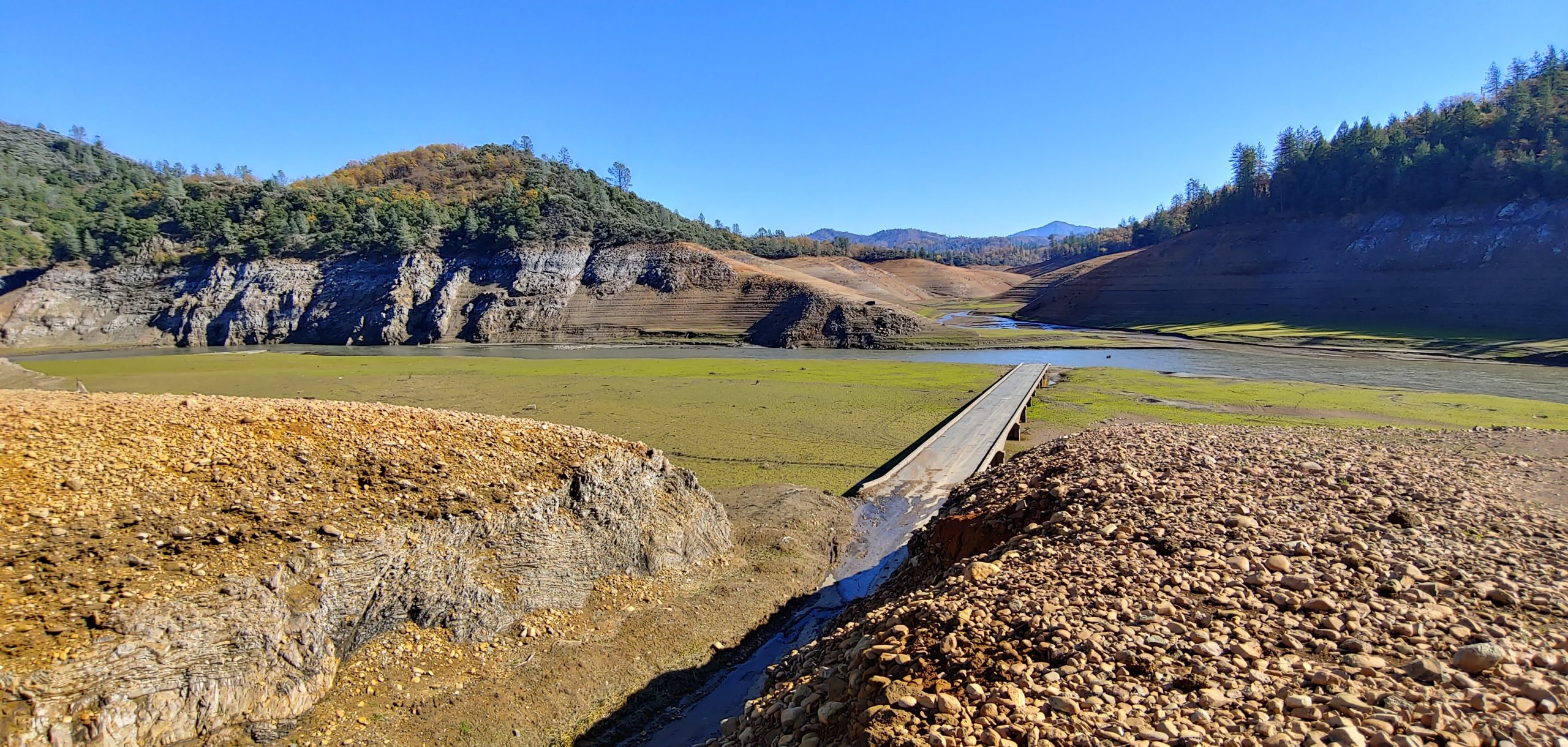
Looking across the 1917 Pollock bridge on old US 99 near Lakehead, CA. Courtesy – Michael F Ballard
Lake Shasta got down to its second lowest level since 1944 when it started filling. On October 21, 2021, the lake reached 882.24′, which is 184.76′ below full pool. By the time I visited on November 9, 2021, the lake had only risen to 889′, still leaving the bulk of US 99 still exposed. Our featured photo shows what that level means. Here, Salt Creek joins the Sacramento River at the former townsite of Pollock. The river has shifted to flow through the townsite itself, with the former river-crossing span left dry. Soot from passing steam locomotives along the former Southern Pacific Railroad can also be seen on the bridge. It is amazing how much is intact despite this bridge only being above water for a few short periods since 1944. As of this writing, the level is still only at 895′.
Errata
Starting January 2022, our meetings with be bi-monthly, as will our newsletters. More information will be posted on our Meetings and Newsletter pages soon.

 The historic structure was restored to its former glory thanks to the generous donation of time and materials by the Rotary clubs of Chowchilla, Madera and Madera Sunrise.