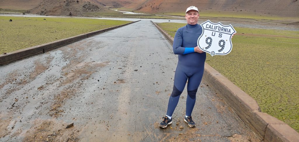
We have a new sticker for sale! Get your own Historic Route US 99 sticker for $5 or sign up for membership! Your donations may be tax deductible as we are a 501(c)(3) organization.
To pay, head over to our Donations page, make a $5 donation, and include your address and note for the sticker.
In an effort to promote Historic US 99 and the history along the way, we are in the process of producing a new web series covering various topics about the road including the Ridge Route, historic route signs, border crossings, and more. Our first video will cover “The Grapevine” in Southern California. If you’d like to help with this project or have an idea of a topic we should consider, let’s talk!
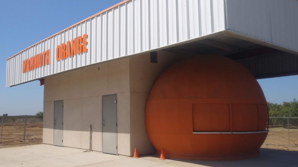
For Immediate Release Media Contact: Kate Holden Director of Public Relations 559-683-4636 kate@yosemitethisyear.com Mammoth Orange to Squeeze Back into the Spotlight at the Fossil Discovery Center of Madera County The historic structure was restored to its former glory thanks to the generous donation of time and materials by the Rotary clubs of Chowchilla, Madera and Madera Sunrise.
MADERA COUNTY, CA – September 8, 2023 – Many long-time residents of California’s Central Valley will remember The Mammoth Orange as a local landmark. The Mammoth Orange was a refreshment stand located on Highway 99 and was known for its giant hamburgers, excellent fries, and out-of-this-world orange shakes.
This historic building is set to make a juicy comeback on Saturday, September 23, 2023, at 6:00 PM, when the Fossil Discovery Center of Madera County invites the public to celebrate a piece of local history with a fundraising dinner and ribbon-cutting ceremony.
The original Mammoth Orange closed in 2007 and was abandoned in a storage yard. Later, the 20-foot orange was brought to the Fossil Discovery Center and painstakingly revived. The structure was carefully restored to its former glory as a concession stand and a San Joaquin Valley attraction, thanks to the generous donation of time and materials by the Rotary clubs of Chowchilla, Madera, and Madera Sunrise.
“We are thrilled to be reopening the Mammoth Orange at the Fossil Discovery Center,” said Michele Pecina, Director of the Fossil Discovery Center. “This iconic landmark is a believed part of our community, and we are excited to share it with a new generation of visitors. The Mammoth Orange is a great example of how history creates unique and memorable experiences.”
The Fossil Discovery Center of Madera County is a museum that houses a collection of fossils, including ancient Columbian Mammoths. It sits adjacent to one of North America’s most extensive middle-Pleistocene fossil excavations, where discoveries continue to this day. The museum offers a variety of educational programs and activities for visitors of all ages.
“The Mammoth Orange is a great addition to the Fossil Discovery Center,’ said Pecina. “It will help us attract more visitors to the museum and learn about our region’s rich history.”
Tickets for the ribbon-cutting event are $25 for members of the Fossil Discovery Center and $30 for non-members. Tickets include a Smashburger meal served from the Mammoth Orange.
The Mammoth Orange ribbon-cutting ceremony is an excellent opportunity to celebrate local and ancient history.
Come one, come all to the Fossil Discovery Center of Madera County on Saturday, September 23, 2023, at 6:00 PM. For more information and to purchase tickets, please visit www.maderamammoths.org or call (559) 665-7071.
About Visit Yosemite | Madera County Formed in 1985, Visit Yosemite | Madera County’s mission is to draw the millions of Yosemite National Park visitors to its gateway’s many businesses and attractions. We invite visitors to take a journey from the Fossil Discovery Center to the Madera Wine Trail and onward to the High Sierra. Discover incredible dining, talented tradespersons, four seasons of water sports at Bass Lake, the Yosemite Mountain Sugar Pine Railroad and mighty adventures right up to the massive Giant Sequoia trees. Madera County is the gateway to so much more.
Yosemite Sierra Visitors Bureau | 40343 Highway 41, Oakhurst, CA 93644
It’s been a while since our last newsletter went out. Things have been somewhat busy on my end, and it isn’t easy to get these going. Help is very much needed and appreciated. We are looking for volunteers to help with the newsletter, articles, and more. Our newsletter is also now going to quarterly, albeit this one was a bit late.
Our Association breaks the state up into four regions. We’d like to put YOU in charge of one of the regions. You can be our regional contact or reporter. You can use the newsletter and website to help promote various events, businesses, and locations along Historic US 99.
Contact us if you have any questions, interested in writing for this newsletter, or giving a presentation for the Association. We’d love to hear from you!
Now onto 99 business. Winter has been a bit harsher lately, with heavy rains and snows along the route. The Ridge Route / Grapevine has been closed at times due to snow and mudslides. Lake Shasta rose quite a few feet over the course of a few days inundating long sections of historic highway. Rare avalanches were visible from I-10 in Beaumont Pass coming down from Mt San Jacinto. All this and we’re not even done yet. To this end, here are some tips for travel over The Grapevine / Ridge Route during winter.
Ridge Route / Grapevine Winter Travel Tips
Tejon Pass on February 25, 2023. Courtesy – Caltrans and Ft Tejon CHP
I-5 between Santa Clarita and the San Joaquin Valley over Tejon Pass is known as “The Grapevine” and formerly known as “The Ridge Route”. It is an important corridor in California and has been so since 1915. Travel over the route can be quite treacherous in winter due to both rain and snow. Mudslides, rockfalls, and ice can all wreak havoc on travel. Caltrans, CHP, and the County of Los Angeles work together to ensure safe travel over the route. Sometimes this can result in a full closure of the pass.
STATS:
Highest elevation – 4144′ at Tejon Pass
Normal Closure Points:
Southbound at Grapevine (Exit 215)
Northbound at Castaic – Lake Hughes Road (Exit 176B)
ALTERNATE ROUTES:
If the 5 is closed, alternate adjacent routes such as Lake Hughes Road are not advisable as they may be in worse condition or be heavily congested. Depending on closures, the best alternative to I-5 is via State 14 (Antelope Valley Freeway) and State 58 over Tehachapi Pass. In times of heavy snow, your only option may well be US 101 to State 46 in Paso Robles. Check with Caltrans and CHP prior to travel to make sure these roads are open.
SPECIAL NOTE:
The Old Ridge Route (Ridge Route Road) is never an alternate to I-5 under any conditions and is not suitable for heavy traffic nor is it open to through traffic.
To stay up-to-date on current conditions, we recommend the following sites:
Quickmap – Caltrans Traffic Map with CHP Incidents and Cameras
Be safe out there and always use caution during winter months when traveling the “Grapevine”.
Membership and Donations
We need your support for our efforts to get Historic Route signage placed in various cities and historic locations such as the Pine and Palm. You can do this by becoming a member, donating money, or by volunteering with our Association. We are a 501(c)3 non-profit corporation and your donations may be tax deductible. Why not help reduce your tax burden for 2023 / 2024 by donating prior? We can also use your help with some of our projects, website, and our newsletter. Having someone local to act as our ambassador or liaison would be of great help. Join now or renew and help us grow!
Pyramid Rock and Cut along the Ridge Route Alternate
Surveying of the new “Ridge Route Alternate”, as it was to be called, began in 1928. The new alignment of the highway would diverge from the existing Ridge Route at Castaic and head north through the mountains via Violin Summit, Whitaker Summit, Piru Gorge, and Peace Valley rejoining the Ridge Route about one mile south of Gorman. From there, the new alignment would follow a much straighter path through Gorman and Tejon Pass. The old summit at Tejon Pass would be lowered from 4213’ to 4183’. The northern terminus of the “Ridge Route Alternate” was Lebec. The name Ridge Route Alternate came from the fact that the Division of Highways thought that people would still travel the original Ridge Route and use the new road as a faster way to travel. Their idea proved false as traffic completely disappeared from the Ridge Route as soon as the new road opened.
In late 1929, construction began on the new Ridge Route Alternate. The new alignment was built to the latest in highway standards. The new route was 9.6 miles shorter and had only 1/14 the curvature of the original Ridge Route. The Ridge Route Alternate was also much lower and more protected which made it less susceptible to fog, sleet, and snow. Instead of two ten-foot lanes on a 24-foot roadway like the Ridge Route had, the new roadway had three ten-foot lanes on a 38-foot roadway. This however only proved to be just as dangerous as two lanes as the center lane was a common passing lane, more commonly known as a “suicide” lane.
In Piru Gorge, massive cuts and fills had to be constructed. The largest cut, known as the Pyramid Cut, was 206 feet deep, 400 feet long, and required the removal of 230,000 cubic yards of material. This left a landmark along the highway that would outlast the highway itself, Pyramid Rock. In total, over 4.3 million cubic yards were excavated and over 30.2 million station yards of overhaul had to be moved. This is 77 times greater than what was moved in the construction of the Ridge Route back in 1915, just 18 years earlier.
Opening Ceremonies at the “Channel Change”
After more than four long years of work, the Ridge Route Alternate was finally opened to traffic on October 29, 1933. Thousands of people attended the ribbon cutting ceremony at the “Channel Change” in Piru Gorge, a change to Piru Creek that saved the cost of two bridges, which is near the halfway point along the route. Many cars were waiting at each end of the new route for the barriers to be removed, which were simultaneously removed at 10 am. Harry A. Hopkins, Chairman of the California Highway Commission, cut the ribbon and formally accepted the Ridge Route Alternate on behalf of the State of California in the name of Governor Rolph. One of the speakers at the ceremony, State Highway Commissioner Phillip Stanton stated that the completion of the Ridge Route Alternate was “the greatest blow to sectionalism in California since the construction of the original Ridge Route in 1915.” He said this because the new “high speed” route through the mountains would allow faster commerce and travel between Northern and Southern California.
Conversion of US 99 to an Expressway from a Three-Lane Highway
As traffic increased through the late 1930’s and the early 1940’s, the need to upgrade the Ridge Route Alternate became evident. Plans and contracts were ready as early as 1940 but World War II delayed those plans. The Collier-Burns Act of 1947 made more funds available from the gasoline tax to upgrade US 99 to an expressway through California. From 1947 to 1951, the Ridge Route Alternate would finally be widened from three lanes to a four-lane expressway. Work began on the first section, the bottom of Five Mile Grade at Castaic to Frenchman’s Flat, on March 13, 1947. The new, wider 78-foot roadway would consist of four twelve-foot lanes, a six-foot dividing strip, and two nine-foot shoulders. Where the divider had to be narrowed to four feet, raised concrete bars were used in the median to separate each direction of travel. The center divider was at its widest at Big Oak Flat, where an unpaved center dividing strip thirty-six feet wide was built.
Instead of concrete, asphalt was used in the paving of the roadway. The grade and curvature were changed just enough so that the original concrete could not be used. It was paved over in some places and completely torn up in others. There are many places where the original concrete is still visible and is usually found about one to two feet below the level of the current roadway. Construction was finally completed June 9, 1948 on Five Mile Grade, February 24, 1949 on the segment from Violin Summit to Whitaker Summit, September 1, 1948 on the segment from Whitaker Summit to Frenchman’s Flat. Widening work was completed through Peace Valley from Los Alamos Creek to just south of the junction of State Highway 138 on December 8, 1949.
By 1951, almost all of US 99 through the mountains was a four-lane divided expressway. Only three segments remained as a three-lane highway – 5.3 miles in Piru Gorge, 11 miles over Tejon Pass, and 5.1 miles in Castaic. Piru Gorge would be the most expensive and most difficult segment to widen. This section extends from Frenchman’s Flat north to the old Oak Flat Maintenance Station. More than 500,000 station yards were moved in the widening of the Piru Gorge segment. As a part of this project, the two bridges at Pyramid Rock were eliminated to save on costs. Instead of widening the bridges, they were removed and replaced with fill as Piru Creek was realigned through the widened Pyramid Cut. All but three miles of that expressway are under Pyramid Lake.
Even with these improvements, fatality rates along Five Mile Grade due to runaway trucks made a runaway truck ramp necessary. It was constructed about 3.5 miles south of Violin Summit and was opened in August 1956. It would be used many times in its 14-year span. The escape ramp was used for the last time in Mid-January 1970 just before the freeway was completed.
September 2022 Meeting and Presentation
Join us via Zoom on Tuesday, September 13, 2022 at 6 pm for a presentation on the Ridge Route Alternate between Castaic and Tejon Pass by Michael F Ballard. To register for the meeting:
I would like to welcome the City of Redlands to our Highway 99 Association. The City of Redlands is our first major sponsor, and we look forward to seeing more in the future. Redlands will also be the first city in San Bernardino County to have Historic US Highway 99 signs posted along its segment. Thanks to their generous donation and application, we can make sure US Highway 99 remains an important part of California history. We hope other cities and organizations follow their lead in the near future.
Remember, When You’re Through Getting Your Kicks on Route 66, Come Wine and Dine on Route 99! There are a lot of good places to do both in Redlands along 99. Come check them out and tell them the Historic Highway 99 Association of California sent you!
The Helen and Joe Chew Foundation, which gave a wonderful presentation in May on the history of the Chinese culture in Red Bluff is looking to raise funds for their cause. If you’d like more information and would like to help, we recommend checking out their website. You can also use the links below to directly contribute. I personally donated $50 toward their Historic Chinatown Signage project. They are a wonderful group with a great cause that needs your support. You can also get a special tour of the area, which is another Highway 99 Adventure, through your membership. Contact us for more details about that benefit.
As we slowly ramp up our efforts to get Historic Route signage placed in various cities and historic locations such as the Pine and Palm, we need your support. You can do this by becoming a member, donating money, or by volunteering with our Association. We are a 501(c)3 non-profit corporation and your donations may be tax deductible. Why not help reduce your tax burden for 2023 by donating prior? We can also use your help with some of our projects, website, and our newsletter. Having someone local to act as our ambassador or liaison would be of great help. We are also working out how to handle renewals for existing members. Initially, we had planned to have all memberships expire at a specific time. At this time, we are looking to have memberships expire at the end of the month initially obtained. Join now and help us grow!
We are working on an article about the town arches along Highway 99 and we need your help. We are seeking photos of the following arches:
Modesto
Lodi
Orland
The photos should show preferably the entire arch. If there is a dedication plaque nearby, we could use help with that as well.
Featured Photo
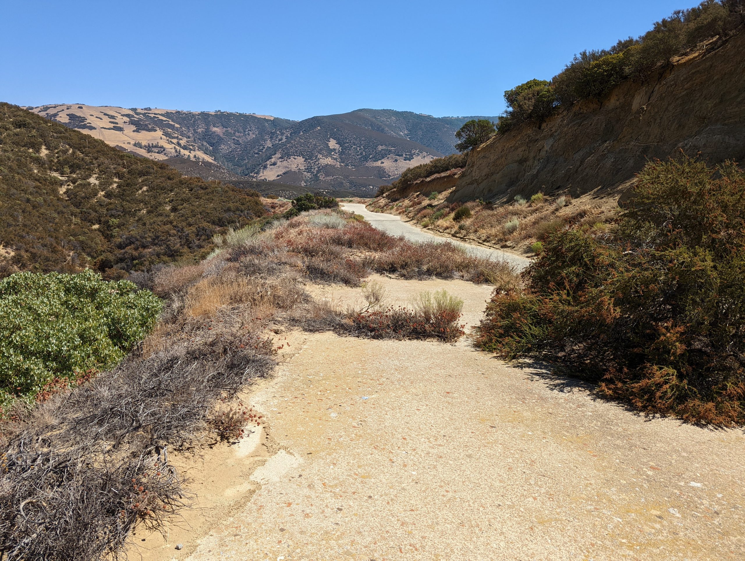
Abandoned section of the Historic Ridge Route near the Tumble Inn site
The Historic 1915 Ridge Route has seen quite a bit of changes since it was first constructed. Among those are the many “curve corrections” which were an effort to reduce the number of sharp curves along the roadway in the mid 1920’s. This particular location was bypassed about 1925, making it nearly 100 years since traffic last passed over it.
 The historic structure was restored to its former glory thanks to the generous donation of time and materials by the Rotary clubs of Chowchilla, Madera and Madera Sunrise.