Greetings Highway 99 Fans!
We’ve created a new Telegram chat channel for Highway 99. All are invited to come over and chat about Historic US 99 in California. Share your stories and meet other Highway 99 enthusiasts.
Historic Highway 99 Association of California
Dedicated to the preservation of California's Main Street – former US Highway 99
Greetings Highway 99 Fans!
We’ve created a new Telegram chat channel for Highway 99. All are invited to come over and chat about Historic US 99 in California. Share your stories and meet other Highway 99 enthusiasts.
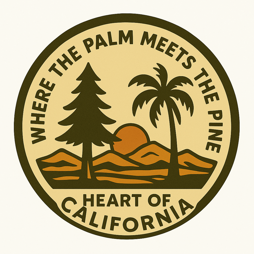
We have new Palm and Pine stickers available for purchase. Other designs are coming soon. Price is $5 each.
If you’d like one, send us a message with Palm and Pine sticker in the subject and we’ll get back to you for payment details. We accept a few methods of payment.
Greetings All!
We are looking for volunteers to help create a design for a Pine and Palm shirt and stickers to help promote and spread awareness of the historic landmark before it goes away in early 2026. The design should incorporate both trees, a US 99 shield, and something to the affect of “Where the Palm Meets the Pine”, “Heart of California”, and “Historic Highway 99 Association of California”. As it will be your design, feel free to include some sort of signature or initials on the design to mark them as from you. If you have a different idea, let us know! We look forward to seeing what you all come up with.
Your design should be submitted by September 15, 2024. The winner will be chosen by members of the Association by October 1, 2024. The winner will receive a $30 gift card to the Historic Saugus Cafe in Santa Clarita and the Second Place winner will receive a $5 gift card to the Saugus Cafe. Both will receive a free one-year membership to the Association.
All submissions should be in either JPG or similar format. Please don’t submit proprietary file formats.
Good Luck and Thank you for your continued support! We can’t do this without you! Use the form below to submit your e-mail address to send your submission to us.
Greetings All!
In an effort to promote Historic US 99 and the history along the way, we are in the process of producing a new web series covering various topics about the road including the Ridge Route, historic route signs, border crossings, and more. Our first video will cover “The Grapevine” in Southern California. If you’d like to help with this project or have an idea of a topic we should consider, let’s talk!
It’s been a while since our last newsletter went out. Things have been somewhat busy on my end, and it isn’t easy to get these going. Help is very much needed and appreciated. We are looking for volunteers to help with the newsletter, articles, and more. Our newsletter is also now going to quarterly, albeit this one was a bit late.
Our Association breaks the state up into four regions. We’d like to put YOU in charge of one of the regions. You can be our regional contact or reporter. You can use the newsletter and website to help promote various events, businesses, and locations along Historic US 99.
Contact us if you have any questions, interested in writing for this newsletter, or giving a presentation for the Association. We’d love to hear from you!
Now onto 99 business. Winter has been a bit harsher lately, with heavy rains and snows along the route. The Ridge Route / Grapevine has been closed at times due to snow and mudslides. Lake Shasta rose quite a few feet over the course of a few days inundating long sections of historic highway. Rare avalanches were visible from I-10 in Beaumont Pass coming down from Mt San Jacinto. All this and we’re not even done yet. To this end, here are some tips for travel over The Grapevine / Ridge Route during winter.
I-5 between Santa Clarita and the San Joaquin Valley over Tejon Pass is known as “The Grapevine” and formerly known as “The Ridge Route”. It is an important corridor in California and has been so since 1915. Travel over the route can be quite treacherous in winter due to both rain and snow. Mudslides, rockfalls, and ice can all wreak havoc on travel. Caltrans, CHP, and the County of Los Angeles work together to ensure safe travel over the route. Sometimes this can result in a full closure of the pass.
STATS:
Highest elevation – 4144′ at Tejon Pass
Normal Closure Points:
ALTERNATE ROUTES:
If the 5 is closed, alternate adjacent routes such as Lake Hughes Road are not advisable as they may be in worse condition or be heavily congested. Depending on closures, the best alternative to I-5 is via State 14 (Antelope Valley Freeway) and State 58 over Tehachapi Pass. In times of heavy snow, your only option may well be US 101 to State 46 in Paso Robles. Check with Caltrans and CHP prior to travel to make sure these roads are open.
SPECIAL NOTE:
The Old Ridge Route (Ridge Route Road) is never an alternate to I-5 under any conditions and is not suitable for heavy traffic nor is it open to through traffic.
To stay up-to-date on current conditions, we recommend the following sites:
Be safe out there and always use caution during winter months when traveling the “Grapevine”.
We need your support for our efforts to get Historic Route signage placed in various cities and historic locations such as the Pine and Palm. You can do this by becoming a member, donating money, or by volunteering with our Association. We are a 501(c)3 non-profit corporation and your donations may be tax deductible. Why not help reduce your tax burden for 2023 / 2024 by donating prior? We can also use your help with some of our projects, website, and our newsletter. Having someone local to act as our ambassador or liaison would be of great help. Join now or renew and help us grow!