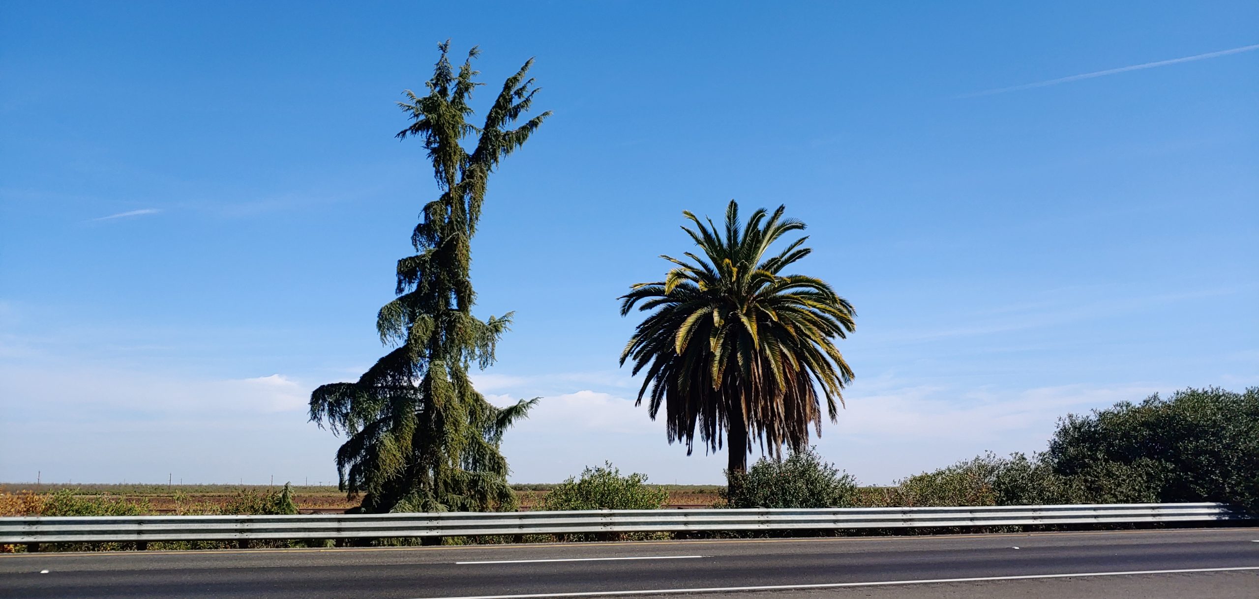
Old routes, destinations, and even locations that have long since disappeared from maps sometimes reappear or never really disappeared on road signs. These “ghosts” appear in many forms, if you know what to look for. Mind you, some are more obvious, as shown in the photo below where a piece of overlay, or “greenout” fell off in early 2023, showing the old sign message.
US 99 revealed on the Ventura Freeway (State 134) in 2023, since covered. Courtesy – Michael F Ballard
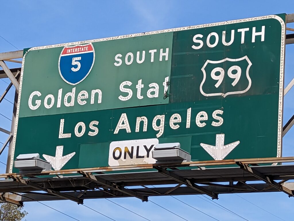
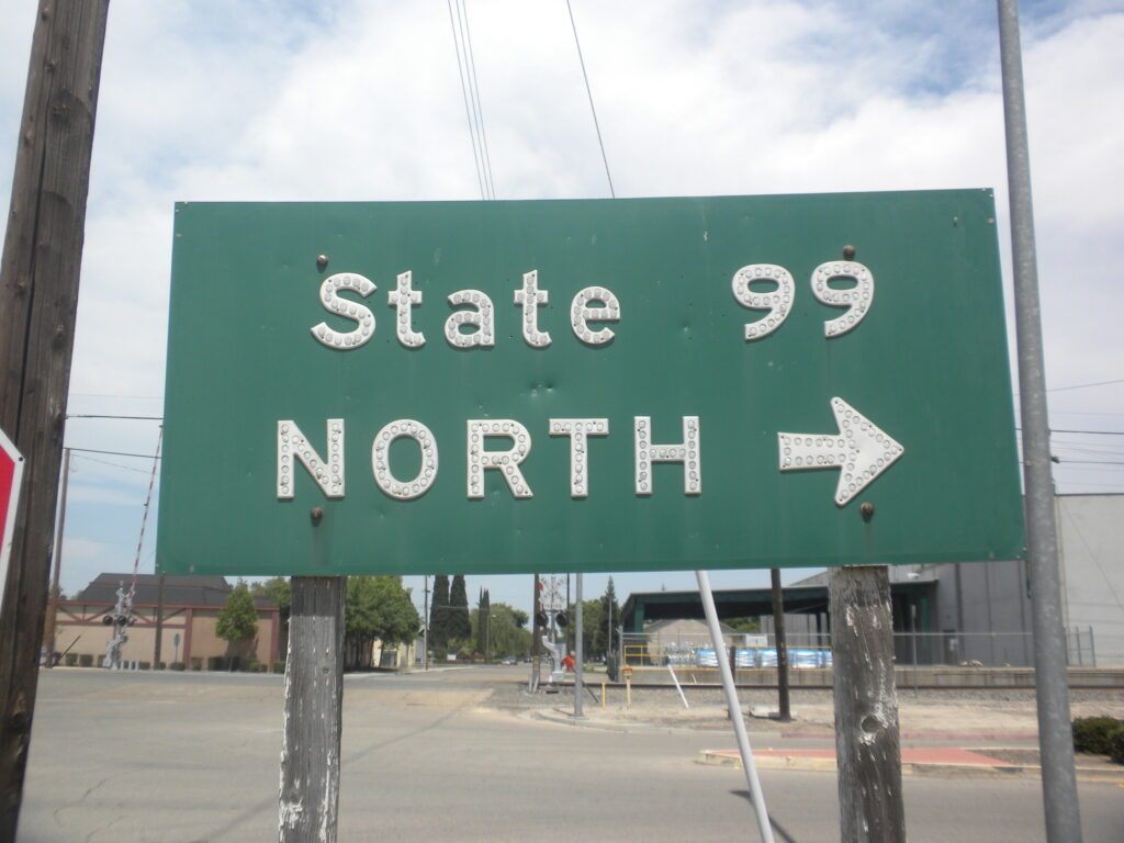
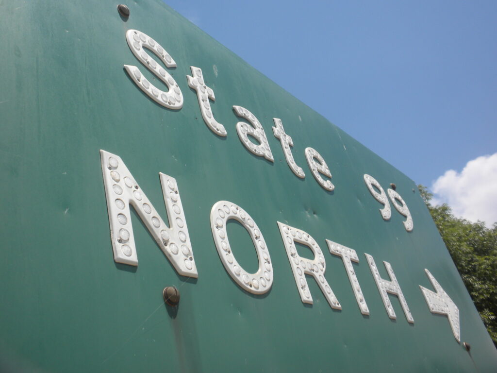
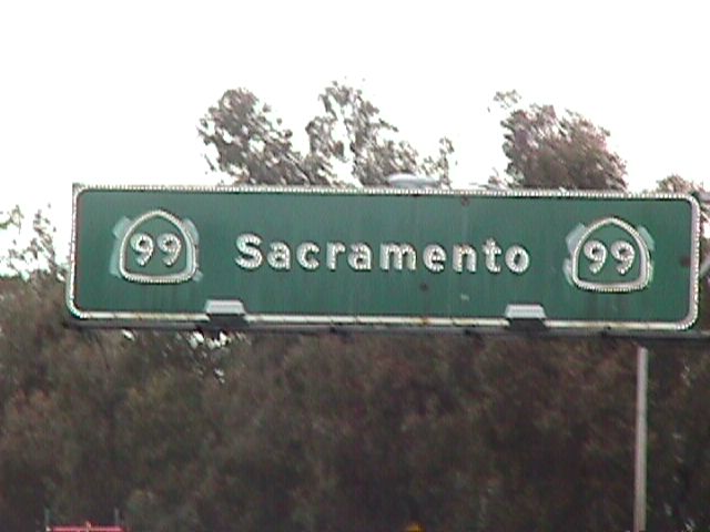
Sometimes the sign is on full display where the message was just modified, such as these signs along 99 where either US was replaced with STATE or the shield shape was modified.
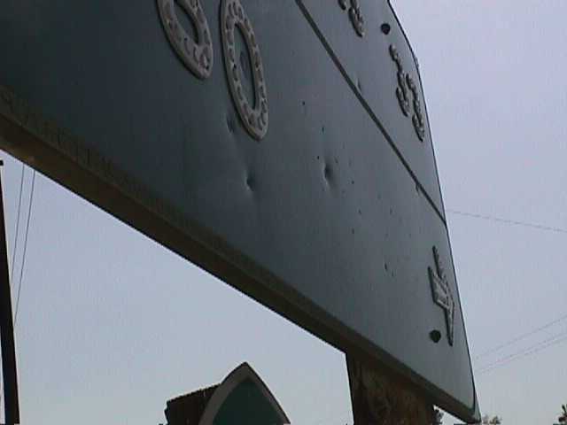
“State” 99, formerly US 99. Courtesy -Michael F Ballard
Note the different holes around the S and both t’s in State, which were to hold U and S. Courtesy – Michael F Ballard
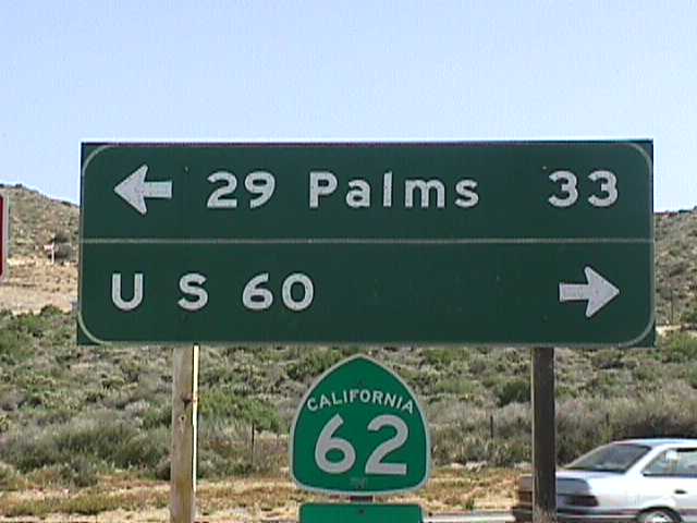
Sometimes not all of the old text was removed. In this case, US 60 remained but, if you look closely, you can spot the holes for a 70 and 99 to the right of the 60.
Old sign at Hess Blvd and State Route 62 in 1998. Courtesy – Michael F Ballard
Note the holes to the right of the 60, which formerly held up a 70 and 99. Courtesy – Michael F Ballard
In some instances, the old route is “peaking out” from under the overlay. Instances of this could be found in Atwater and Beaumont until not all that long ago.
Atwater US 99 “ears” in 1998. Courtesy – Michael F Ballard
US 60 peaking out from under a State Route 60 overlay at Beaumont. US 99 followed the 10. Courtesy – Michael F Ballard
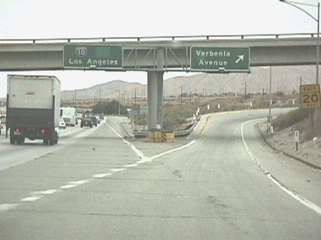
Other signs had complete overlays placed but was still obvious that there was something more. Usually in these cases, the alignment of the shields was a clue or the different colored panels that were placed.
Late 1990’s view of the former Verbenia Ave exit sign on westbound I-10. Note the panel to the right of the 10 shield. It is covering a US 99 shield. Courtesy – Michael F Ballard
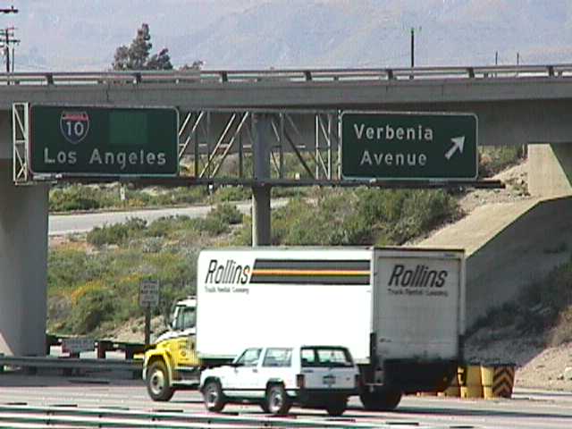
Another angle on the Verbenia Ave sign with the overlay panel still quite obvious. Courtesy – Michael F Ballard
Signage at the west end of 6th St in Beaumont. Everything except the 10 is an overlay here. US 60 is covered by State Route 60. The light colored panel to the right of the 10 covers US 70 and US 99. Courtesy – Michael F Ballard
As you can see, there are many ways old routes can be found on signs. Even if covered, document everything you find. You really never know when one of these will be replaced or might perhaps reveal a “ghost” from the past. If we have missed. let us know and we’d be happy to showcase it on our site, with proper credit of course.
I wanted to give some updates on the Pine and Palm. I recently had a meeting with Caltrans District 6 to discuss the project and what our intentions are for the landmark trees.
Signage
We explained that, while we appreciated and liked their idea of planting more trees along the southbound side of the roadway, we would like to see a marker or sign placed in both directions to help commemorate the site and increase public awareness of the landmark itself. They agreed this would be a good idea in concept but were uncertain if it could gain approval as the signs as proposed may not be MUTCD compliant. The main issue was with the graphics of the pine and palm itself, as they are not standard for signage. Should the sign be approved, that portion of the sign would likely have to be removed. There is precedent for such a sign in Oregon which marks the 45th Parallel along I-5. The Pine and Palm are similar in nature, though not as specific, so that should help us in our quest for approval. We look forward to finding a way to make this happen.
Median Barrier
Caltrans also is looking into putting something on the median barrier itself, which has been done in many other locations through the state. These, in addition to the signs and new trees, should help mark the site and its significance. We are confident we can make something happen at the Pine and Palm site, even if it takes longer than construction.
Existing Trees
The existing trees may not likely survive, unfortunately, due to the problems of moving such plants. If they are moved, those accepting the trees may have to bear the costs of the move, which can be prohibitive to some. Their disposition isn’t likely to be known for a while and we will try to keep everyone informed as to where they end up. For now, we have until early 2026 before they are torn down, so make sure to enjoy them while they last.
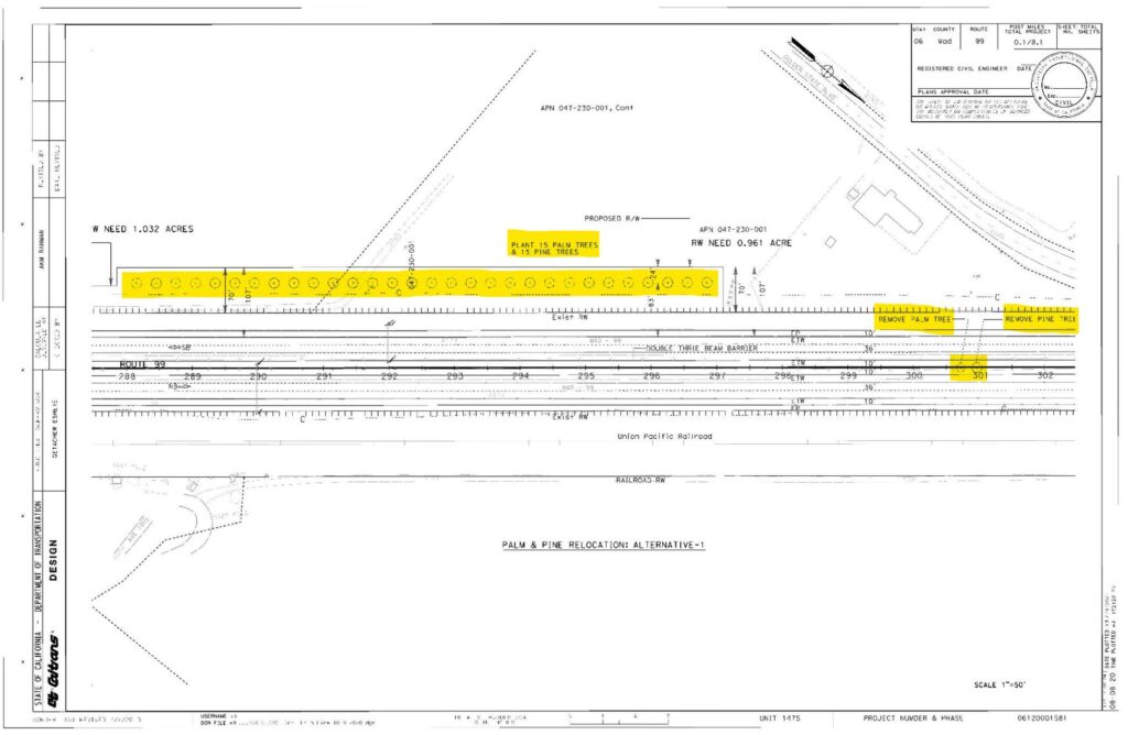
The Caltrans project calls for planting 15 new pine and palm trees along the southbound side of the roadway 330 feet south of the existing location.
Caltrans Proposal for new trees in relation to the existing trees
Design Help
As a side note, we are looking for an artist to design a “Pine and Palm” logo for placement on t-shirts and stickers which we’d like to sell. Let us know if you’re interested in helping us with this project. We are looking to get things started soon.
Just south of Madera, 1.75 miles south of Ave 12, and 2.1 miles north of Ave 9 (or more specifically at 06-MAD-99-05.7), there lies a pine tree and a palm tree in the median of Highway 99. It has been there since the 1920’s and marks the former halfway point in California. The Palm Tree, a Canary Island Date Palm, represents Southern California and the Pine Tree, a Deodor Cedar, represents Northern California. In 2005, the pine tree fell down but was replaced by Caltrans in 2007 as this is a somewhat historic marker. In the next couple of years, Caltrans District 6 intends to remove the Pine and Palm for a highway widening project. New trees are planned to the west of the current site but no marker at this time. For more information about this Caltrans project, please go to the link below:
We, the Historic Highway 99 Association of California, intend to have signs placed in both directions at this location to mark the historic site. While it might not exactly be the “halfway” point in California, it is close enough and has been there since the 1920’s. We are looking to work with local agencies such as the County of Madera, Caltrans District 6, City of Madera, and others to gain support and assistance with this effort. We already have a tentative design for the sign and cost estimates for its fabrication.
If you would like to be involved in this project (03-MAD21002), let us know! We can use help either through donations of labor or money. Any donations are likely tax-deductible as we are a 501c3 organization.
It’s been a while since our last newsletter went out. Things have been somewhat busy on my end, and it isn’t easy to get these going. Help is very much needed and appreciated. We are looking for volunteers to help with the newsletter, articles, and more. Our newsletter is also now going to quarterly, albeit this one was a bit late.
Our Association breaks the state up into four regions. We’d like to put YOU in charge of one of the regions. You can be our regional contact or reporter. You can use the newsletter and website to help promote various events, businesses, and locations along Historic US 99.
Contact us if you have any questions, interested in writing for this newsletter, or giving a presentation for the Association. We’d love to hear from you!
Now onto 99 business. Winter has been a bit harsher lately, with heavy rains and snows along the route. The Ridge Route / Grapevine has been closed at times due to snow and mudslides. Lake Shasta rose quite a few feet over the course of a few days inundating long sections of historic highway. Rare avalanches were visible from I-10 in Beaumont Pass coming down from Mt San Jacinto. All this and we’re not even done yet. To this end, here are some tips for travel over The Grapevine / Ridge Route during winter.
Ridge Route / Grapevine Winter Travel Tips
Tejon Pass on February 25, 2023. Courtesy – Caltrans and Ft Tejon CHP
I-5 between Santa Clarita and the San Joaquin Valley over Tejon Pass is known as “The Grapevine” and formerly known as “The Ridge Route”. It is an important corridor in California and has been so since 1915. Travel over the route can be quite treacherous in winter due to both rain and snow. Mudslides, rockfalls, and ice can all wreak havoc on travel. Caltrans, CHP, and the County of Los Angeles work together to ensure safe travel over the route. Sometimes this can result in a full closure of the pass.
STATS:
Highest elevation – 4144′ at Tejon Pass
Normal Closure Points:
Southbound at Grapevine (Exit 215)
Northbound at Castaic – Lake Hughes Road (Exit 176B)
ALTERNATE ROUTES:
If the 5 is closed, alternate adjacent routes such as Lake Hughes Road are not advisable as they may be in worse condition or be heavily congested. Depending on closures, the best alternative to I-5 is via State 14 (Antelope Valley Freeway) and State 58 over Tehachapi Pass. In times of heavy snow, your only option may well be US 101 to State 46 in Paso Robles. Check with Caltrans and CHP prior to travel to make sure these roads are open.
SPECIAL NOTE:
The Old Ridge Route (Ridge Route Road) is never an alternate to I-5 under any conditions and is not suitable for heavy traffic nor is it open to through traffic.
To stay up-to-date on current conditions, we recommend the following sites:
Quickmap – Caltrans Traffic Map with CHP Incidents and Cameras
Be safe out there and always use caution during winter months when traveling the “Grapevine”.
Membership and Donations
We need your support for our efforts to get Historic Route signage placed in various cities and historic locations such as the Pine and Palm. You can do this by becoming a member, donating money, or by volunteering with our Association. We are a 501(c)3 non-profit corporation and your donations may be tax deductible. Why not help reduce your tax burden for 2023 / 2024 by donating prior? We can also use your help with some of our projects, website, and our newsletter. Having someone local to act as our ambassador or liaison would be of great help. Join now or renew and help us grow!
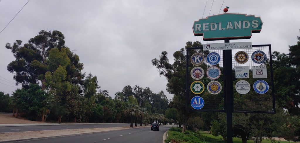
I would like to welcome the City of Redlands to our Highway 99 Association. The City of Redlands is our first major sponsor, and we look forward to seeing more in the future. Redlands will also be the first city in San Bernardino County to have Historic US Highway 99 signs posted along its segment. Thanks to their generous donation and application, we can make sure US Highway 99 remains an important part of California history. We hope other cities and organizations follow their lead in the near future.
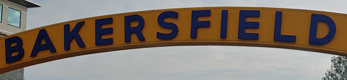
Remember, When You’re Through Getting Your Kicks on Route 66, Come Wine and Dine on Route 99! There are a lot of good places to do both in Redlands along 99. Come check them out and tell them the Historic Highway 99 Association of California sent you!