We are looking for a new Treasurer for our board of directors. Ideally, we would like to have someone with experience with the forms required to be submitted by non-profit organizations such as ours. At a minimum, we are seeking help with our forms to ensure this organization remains up to date with the State and Federal governments.
We look forward to hearing from you soon! Thank you all for your continued support!
Over the Thanksgiving holiday weekend, one of our recently placed signs was stolen in Madera. Our northernmost sign on Gateway Drive, a 24×36 sign, was taken. The City informed me of this shortly after and we worked on a solution. We agreed the sign wasn’t in the safest place and will be relocated to a better location once it is replaced. Future signs will also be marked by the City to reduce problems with theft and potential resale of the signs.
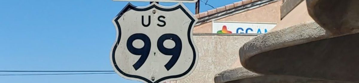
In early November, we went on a trip up to Northern California to see Lake Shasta in person, among many other things. Over the course of the US 99 portion of the trip, we took approximately 1200 photos, the bulk of which were at Lake Shasta. In addition to photos, some videos were also taken covering some of the highlights of the trip. Those videos have been posted to our YouTube channel. We are also planning a presentation covering Lake Shasta in early 2022.
We are also in need to a Treasurer for our Association. If you would like to join our board, help us grow as an Association, and can help with fundraising, let’s talk! We are a small group and can use the help.
Our December meeting is tonight at 6pm! Come join us and learn about what is going on with the Association, our future plans, and hear our guest speaker from the Historic Ukiah-Tahoe Highway Association talk about the historic roadway and its link with US 99. Register using the link below.
Contemporary photo shows Route 46 & abandoned Route 466 to the right of pic.
Sandy and I live eight miles East of Auburn in Cool, California. We enjoy vacationing every year at Avila Beach. Driving the roads to picturesque Avila Beach is where this story begins.
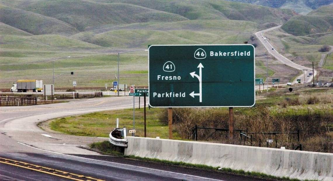
From Cool we travel South on I-5 and turn off at State Route 41 and cross over onto Route 46 west at the junction; and then onto the 101 south toward Avila Beach. The junction of Routes 41 and 46 are in the middle of nowhere, at the end of a long drive; and even though I had seen the sign marking the “James Dean Memorial Junction” more than once—what I was reading didn’t register with me for two or three years. Finally, I had to ask: “Was this lonely Y Junction, located in a cow pasture among the parched & rolling foothills of San Luis Obispo County, the place where the world-famous actor was killed in a nearly head-on collision?” It didn’t seem possible to me. I began looking closely into this accident and James Dean’s short life. It became an ever-expanding whirlpool of persons / time / places and happenstance. And, oh yes, it’s a tale of some very bad driving.
James Dean’s last picture was “Giant” staring Rock Hudson and Elizabeth Taylor. James Dean had a supporting role in that movie.
Elizabeth Taylor’s number 4 husband was Eddie Fisher. In his autobiography, Eddie, wrote this about Elizabeth after their 1964 divorce: “Ah, Elizabeth Taylor! She is every man’s dream, the most beautiful woman in the world… with the morals of a truck driver!”
About two weeks after Dean competed filming his part in “Giant” he was off to the races.
Dean had a reputation of taking a lot of unnecessary risks when driving hot cars or motorcycles on public roads. More recently he had taken up car racing in the Southern California area. On September 30, 1955, Dean and his Mechanic Rolf Wütherich were on their way to enter Dean’s brand-new “Little Bastard” Porsche in an SCCA Club race being held at the Salinas Airport. There were two options when it came to getting the Spyder to the race track: Dean could’ve used his personal tow vehicle and a trailer he borrowed to haul his car, which was the original plan. Or he could’ve driven his Spyder on the streets, in traffic, over the long drive to the track. He chose the latter, which was not unusual for the competitors in this race to do. However, in his memoir, “Jimmy & Me”, friend and follow race car driver, Lew Bracker, wrote that he would never have let Dean drive that car to the track if he had known about it before hand.
In 1955 there was no Interstate-5, rather, there was HWY 99 running North and South along a somewhat similar alinement. Also, there was no State Route 46 as of yet. The road being used at that time was Route 466.
James Dean and his mechanic Rolf Wütherich drove north from the Sherman Oaks area to join HWY 99. Later, he drove over the four-lane Ridge Route Alternate [HWY 99]. When he made a short stop at Blackwell’s Corner, he bragged to fellow racecar driver, Bruce Kessler, that he had driven his Porsche Spyder 550 at one hundred and twenty mph over a section of HWY 99. Most likely a downhill section in the Wheeler Ridge area.
Rolf Wütherich was a German national who was employed in the Porsche Factory”s racing department. During World War II, he served in the Luftwaffe as a teenaged glider pilot; paratrooper and aircraft mechanic. His time in the Luftwaffe instilled in him the lifetime love of high performance machinery on which he later became an expert. It is rumored that taking on the more mature Wütherich as Dean’s ‘race team’ was part of a deal in getting the owner of Competition Motors, Johnny von Newman, to agree to sell the Spyder to James Dean in the first place. Von Newman definitely didn’t think that Dean had enough racing experience to handle the latest and more powerful model. Dean already owned a Porsche Super-Speedster 356, which was considered more of an entry level racer as compared to the Spyder 550.
The fatal wreck occurred at the junction of State 41 and US 466, near the town of Cholame, California, when a Cal Poly student, who was headed east on 466, made a left-hand turn at Route 41 in front of Dean’s oncoming Spyder, which was heading west on 466. Both drivers were exceeding the posted speed limit, however, I’ve been over both Routes 46 and 41(not to mention over the remains of old 466) and nobody drives at the posted speed limit in that area—including myself—and I don’t think anybody ever has. Just how fast Dean was driving is a subject of considerable controversy to this day. The controversy started with the two original investigating CHP officers who couldn’t agree on which party was to blame or how fast the drivers were traveling. During the wreck, Rolf was thrown clear of the Spyder and survived, but spent a year in the hospital and likely had some very ugly and permanent personality changes that got him into serious trouble.
As for myself, I’ve hiked over all the remaining sections of old Route 466 in the Polonio grade area of Antelope Road [CA 46] in both directions a number of times. There are three distinct remaining sections—Starting at the Antelope Exit near a place called Poison Water Pond that can be seen on Google Earth, you can walk west unimpeded all the way to the Memorial Junction. Also you can walk east from the same starting point [Antelope Exit] to where old 466 has been buried under the modern Route 46. You’ll have to climb over one barbed wire fence in the small parking area to get onto this section. There is another short section on the North side of 46, which actually is a continuation of old 466 as it comes out from under the 46 roadbed mentioned above. This last section is accessed from 46 westbound and is just across 46 from the Polonio Pass Pumping Section. The entire 466 remains total about seven miles in one direction give-or-take. Old 466 throughout the Polonio Pass area looks more like the 1915 era Ridge Route through the Tehachapi Mountains than it does the modern California, State Route 46.
I’ve heard that some people have driven motorcycles over some or all of historic 466. I think you would need an ATV to drive over all of 466 in a four wheel vehicle. Personally, I wouldn’t take a motor vehicle up there because it damages the exposed road surfaces and increases your chance of being spotted. Keep in mind that all of the remaining sections are on 100% private property. Standing out might get you stopped. Also, I would never take a pet dog with me to 466 because it’s a cattle ranch, and ranchers have the legal right to shoot any dog that they even think is worrying their cattle and / or you might get a visit from the CHP. However, I think the odds of any of that happening to you are pretty low. Plan your visit to the James Dean Memorial Junction area in the spring time to see the beauty of the green hills and flowers in bloom.
There are a number of interesting side trips to take regarding James Dean history in the Junction area. Blackwell’s Corner has been on 46 since before there was a 46 and long before Dean stopped there on his last ride. In fact, it was the last controlled stop he ever made. Blackwell’s has a small James Dean museum in the far corner of the shop, which includes Dean’s driving goggles picked up on 466 immediately after the accident (one rumor has it that these googles were actually being worn by Rolf on that day). Blackwell’s Corner Store is a great place to shop for olives; pickles and many other delicacies. It’s a must stop for Dean Fans. How James Dean got to the Blackwell’s Corner area, and beyond, is also a subject of controversy. He either drove north on HWY 99 toward Famoso, the city lost in time, and then turned directly onto 466 westbound, or he took, the so-called “Racers Road”, which starts at the HWY 99 cutoff onto 33/166 toward Maricopa and the town of Taft et cetera. The oil derricks along the Racer’s Road are reminiscent of scenes out of the movie “Giant”. Both these routes go by Blackwell’s Corner. I’ve driven over these two routes in both directions a number of times as well. Frankly most of this countryside is ‘lost in time’. Many places look as if they haven’t changed since 1955. I like driving through this general area—it’s an instant ‘History Rush’, for me.
I would like to give a shout out to some of the people I’ve asked questions of over several years regarding James Dean and his final ride.
Shannon Wafford, who fact-checked this article and made helpful suggestions, has hosted the annual James Dean Memorial run for the last six years; and has learned a great deal of insider’s information & made many invaluable contacts along the way. This run starts in Hollywood and ends in Salinas (you can pick it up on any part of the route with previous arrangement with Shan). Shan is a film maker and custom car builder with some 30 years of experience. He knows how cars perform on the race track. http://www.facebook.com/jamesdeanslastdrive
Michael Ballard who encouraged me to write this article. He has an encyclopedic knowledge of all the SoCal highways and byways; and their histories. He must have an amazing photographic memory:
Harrison Irving Scott who was very personally moved when he first heard that James Dean had been killed when it occurred back in 1955. Scottie is the very embodiment of the Ridge Route’s history today. He has written two books regarding the Ridge Route and a number of articles and has given many interviews. He was the subject of Huell Howser’s “Road Trip America” the “Ridge Route-2003 Season 1 Episode 22”: http://www.ridgeroute.com/
Lee Raskin took the time to answer my many questions regarding James Dean early on. He is the author of excellent books on this and related subjects, including “James Dean on the Road to Salinas” 2015 :
I’ll attempt to answer questions you may have… as others have answered my questions:
manxcat2@sbcglobal.net
December Presentation
Join us on December 7th, 2021 for a presentation on the Historic Ukiah-Tahoe Highway Association by Mike Herman. He will discuss the Historic Ukiah-Tahoe Highway Association and a Travel Guide that he wrote about Historic US 99W in California, “The Forgotten Highway”. At this meeting, we will cover some of the ups and downs of trying to get the Association started. We will also discuss how this turned into writing several Travel Guides including the one about US 99W. We hope that you can attend the Zoom Meeting on Dec. 7th at 6pm.
We restarted our online discussion forums for Historic Highway 99. Come join in! Tell your Highway 99 stories, discuss your favorite place along the road, learn about the history, and more!
Things are looking up! We have a few projects in the works at various levels now. In Madera County, we are working on posting signs to mark the Pine and the Palm along Highway 99. At this time, we are in the design phase for the signs. We are also looking into getting it designated a “Historic Landmark”, which is something we will need help with. We intend to work with local historical societies, Madera County, and Caltrans to get this done.
We will also be working with Caltrans District 2 to have Historic Route signs posted along State Highway 263 between Yreka and Hornbrook along the Historic Shasta River Canyon alignment. After surveying the route, we have determined that six signs should be posted. These signs would be posted at the 3/263 junction, 1931 Pioneer Bridge, and at the 96/263 junction.
If you have an idea for a project for the 99 Association or would like to get involved, let us know!
Board Position Open
We are currently seeking a Treasurer for our organization to manage our finances and be a part of the decision-making process. If you are interested, or know someone that might be, contact us. We’d love to have you as a part of our team and help keep Historic US 99 alive in California!
Membership and Donations
As we slowly ramp up our efforts to get Historic Route signage placed in various cities and historic locations such as the Pine and Palm, we need your support. You can do this by becoming a member, donating money, or by volunteering with our Association. We are a 501(c)3 non-profit corporation and your donations may be tax deductible. Why not help reduce your tax burden for 2022 by donating prior to the new year? We can also use your help with some of our projects, website, and our newsletter. Having someone local to act as our ambassador or liaison would be of great help.
We do wish to thank all those that have donated and become members thus far. Our most recent project in Madera couldn’t have happened without your support!
Looking across the 1917 Pollock bridge on old US 99 near Lakehead, CA. Courtesy – Michael F Ballard
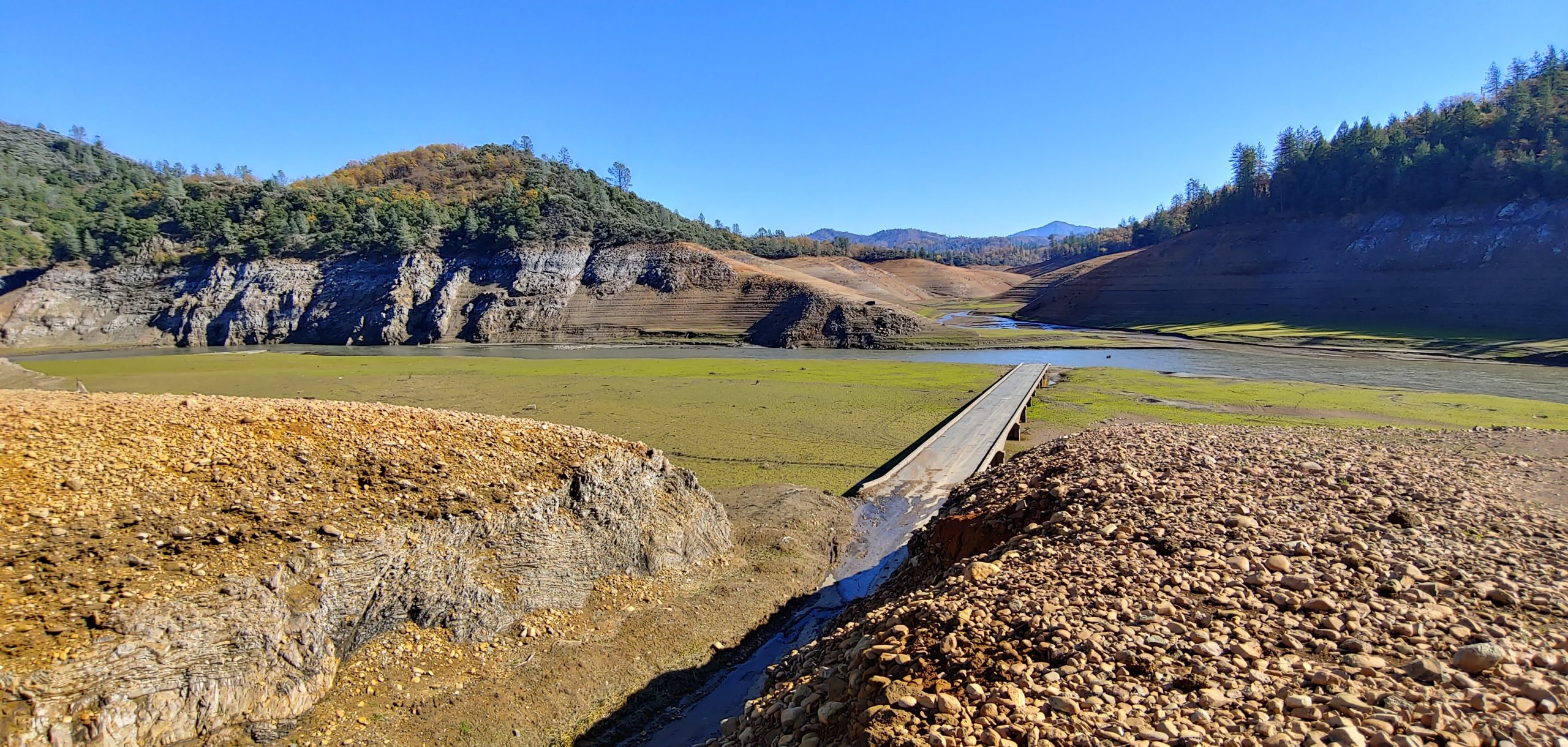
Lake Shasta got down to its second lowest level since 1944 when it started filling. On October 21, 2021, the lake reached 882.24′, which is 184.76′ below full pool. By the time I visited on November 9, 2021, the lake had only risen to 889′, still leaving the bulk of US 99 still exposed. Our featured photo shows what that level means. Here, Salt Creek joins the Sacramento River at the former townsite of Pollock. The river has shifted to flow through the townsite itself, with the former river-crossing span left dry. Soot from passing steam locomotives along the former Southern Pacific Railroad can also be seen on the bridge. It is amazing how much is intact despite this bridge only being above water for a few short periods since 1944. As of this writing, the level is still only at 895′.
Errata
Starting January 2022, our meetings with be bi-monthly, as will our newsletters. More information will be posted on our Meetings and Newsletter pages soon.
On November 23, 2021, we celebrate our first year as a California Non-Profit Public Benefit Corporation! We have done a lot in our first year and have a lot more to do in the future. In March 2021, we posted our first signs in the city of Calexico and were granted our 501(c)3 status. We also started memberships at the time. Our memberships are growing and now cover California, Oregon, Washington, and British Columbia. In September 2021, we worked with the city of Madera to post new signs along their portion of Historic US 99 known as Gateway Drive. We’ve been in two newspapers so far because of these projects.
I am very proud of what we have been able to accomplish in such a short period of time. We could not have done any of this without all your support and wish to thank all that have contributed their time and money toward our efforts. We also would love to hear from you! What are your thoughts about what we’ve done? Would you like to help? We need your help to represent us throughout the state. We’d love to hear your feedback.
US 99 and Newhall Pass – Part 2
by Michael F Ballard
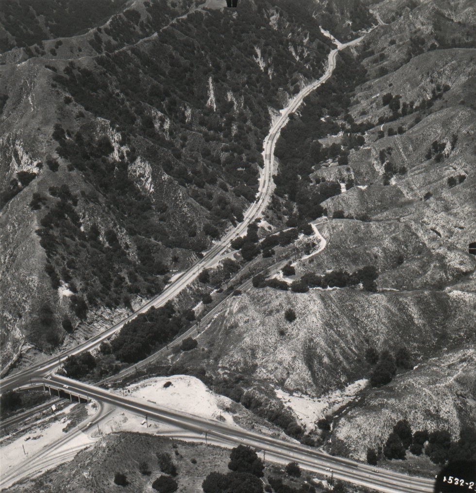
Looking north through Weldon Canyon in 1949. Courtesy – Caltrans.
Upgrading to a Four Lane Expressway
By the early 1940’s, it became evident that yet another improvement had to be made to the highway. World War II postponed most of the planned improvements for US 99. A plan to widen US 99 to four lanes along its entire course was begun in 1947. On June 24, 1948, a contract was awarded for a 3.3-mile segment, Saugus Junction to Pico Canyon. It was completed on April 8, 1949. In this case, the widening was cheaper, costing only $450,000, as only minor realignments had to be done. The old lanes were used for the northbound side and a new set of lanes was added for the southbound side. The Weldon and Gavin Canyon sections were finally widened to a four-lane expressway in 1951. The old concrete could not be used and had to be demolished, as this section required considerable straightening. The new lanes were made of eight-inch concrete 24 feet wide with a division strip of varying width. These two new roadways had asphalt shoulders that were eight feet wide on the right and five feet wide on the left. The realigning of the roadway involved the excavation of over 700,000 cubic yards. Total cost for this section amounted to about $1 million.
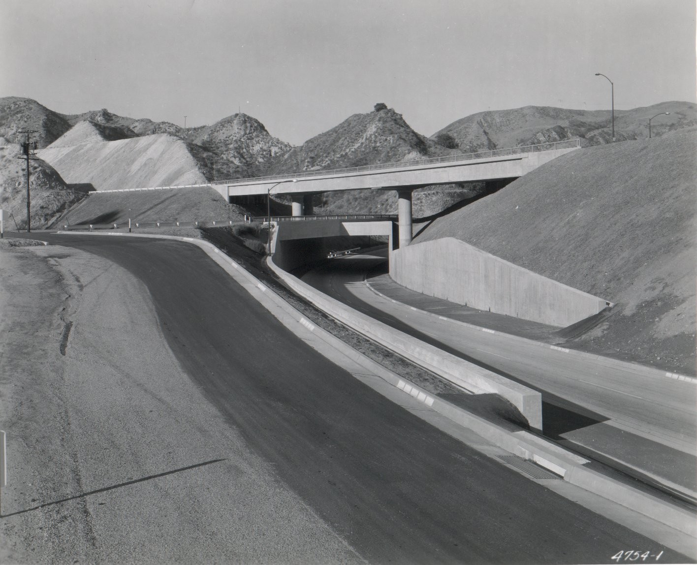
By 1953, traffic had increased to the point where the next step had to be taken – grade separations. The first section of freeway was completed in 1954. It ran from San Fernando Road near Sepulveda Boulevard (Sepulveda Junction) to the base of Weldon Canyon. This new freeway had many features which greatly improved traffic flow through here. A three-level interchange was constructed at the junction of US 6 and US 99. Direct ramps were constructed to connect northbound US 99 traffic to northbound US 6 and southbound US 6 traffic to southbound US 99.
Three-Level Interchange at US 6 and US 99 in 1955. Courtesy – Caltrans.
Upgrading to an Interstate
The first segment of US 99 in the Santa Clarita Valley to be reconstructed as an Interstate was between Saugus Junction and Castaic Junction. That freeway, completed in 1964, still carried US 99 shields on the overhead signs. This was done to ease the transition to I-5 from US 99. The completion of the freeway eliminated two major traffic signals along the old highway. From 1967 to 1968, the rest of old US 99 was upgraded to a full freeway. The original freeway through Newhall Pass is now used as the truck route and has been since the interchange was reconstructed with State Highway 14, the Antelope Valley Freeway. The new interchange is located just a half mile northwest of the old interchange.
Earthquakes and Newhall Pass
On the morning of February 9, 1971, it was still under construction when the Sylmar / San Fernando earthquake struck. Most of what was built collapsed, killing two people in a pickup truck below. It also crushed a newly constructed crane, which was set to be used for the first time that Tuesday morning. The interchange was subsequently rebuilt and finally completed in 1975. However, on January 17, 1994, two of the bridges collapsed in the Reseda / Northridge earthquake. It took less that a year for the interchange to be rebuilt which is remarkable for reconstruction of a major, and functioning, freeway interchange. The old expressway in Gavin Canyon was used as a temporary freeway after the Gavin Canyon overpasses partially collapsed leaving one big rig and a few cars stranded on an island in the sky. The original 1951 concrete was paved over at that time. The center concrete barrier and metal guardrail were also added at that time.
Highway 99 In the News
We were in the news on Saturday, October 9, 2021! The Madera Tribune, a local paper covering Madera County, printed the press release that was issued by the City of Madera for our latest signing project. Getting ink, no matter how, is pretty cool. Every little bit helps with awareness of our organization and spreading the word of our goals.
A look at where the Lincoln Highway, America’s first Transcontinental Highway, 1913-1927, meets Highway 99 in California Central Valley. We will discuss why the Lincoln Highway chose the central valley route to Altamont Pass instead of a more direct one. Hint, there wasn’t any. When the Lincoln Highway ceased to exist, the number system Highway 99 took over from Sacramento south. We will look at some places where you can still see some of the histories of these two famous roads.
Along with his wife Monica, Trey created “Adventures in California History,” an ongoing exploration of historic California. Trey is currently the Vice-President of the Lincoln Highway Association.
Join us on November 2, 2021 at 6 pm for a Zoom presentation.To register, please use the link below:
We are looking to expand our organization. With the number of cities interested in Historic Route signage growing, we need your support! Donations big and small are also welcome. Any donation above $20 will include an optional one-year membership. We are also working on a potential “Lifetime” membership, which will be above a specific donation amount.
Signing up is easy! Join us as a member and help us grow!
We restarted our online discussion forums for Historic Highway 99. Come join in! Tell your Highway 99 stories, discuss your favorite place along the road, learn about the history, and more!
Things are looking up! We have a few projects in the works at various levels now. In Madera County, we are working on posting signs to mark the Pine and the Palm along Highway 99. We are also looking into getting it designated a “Historic Landmark”, which is something we will need help with. We intend to work with local historical societies, Madera County, and Caltrans to get this done. If you have an idea for a project for the 99 Association or would like to get involved, let us know!
Board Position Open
We are currently seeking a Treasurer for our organization. If you are interested, or know someone that might be, contact us. We’d love to have you as a part of our team and help keep Historic US 99 alive in California!
Featured Book
On Creating Our Highway 99 Books
By Jill Livingston
The occasional sighting of the abandoned Dog Creek Bridge off to the side of I-5 in the Sacramento River Canyon never failed to thrill, and frequent drives through the rocky, bridge-bejeweled Shasta River Canyon on old 99 finally prompted an “aha moment.” My sister and I looked at each other and said, “Someone should do a book about this! Shall we? Can we? How?” And the fact that these northern artifacts are connected to that long, hot highway through the Central Valley we often traversed as kids, and later traveled 99 north on a trip to the 1962 World’s Fair in Seattle made this two-lane highway all the more intriguing.
But this was 1994. Back in those ancient days the internet was barely emerging, so doing research was not an easy thing. Nor was “self-publishing.” Our research started simply with driving around and looking for segments of old highway. I have to think that when we found something, it was much more satisfying than the way it goes nowadays; finding out on Facebook that a segment of old road is in such and such a location, go see it. Our trips were truly trips of discovery! I’ll never forget how excited we were when we stumbled upon the old Salt Creek Bridge that had appeared with a lowering Shasta Lake (yes, there were dry years back then too.) And along the way in our travels we visited any local history museums we could as well as the CalTrans Library in Sacramento and Bancroft Library in Berkeley. I even found a few gems in our small local library, such as the Depression era WPA California guidebook with its colorful descriptions of towns along the way.
After considerable trial and error, we came up with a good format for our books: background history in the chapters, a pictorial Tour (using both contemporary and historic photos), a road log and maps in the back. I’m proud that one reviewer called the Ribbon of Highway series the “seminal” Highway 99 books. Several other books have come out since our first publication as this hobby (obsession?) has grown in popularity, and every one contributes to the story. Over time we published new improved editions and covered the entire highway from Canada to Mexico in three books.
It’s sad that so much roadside archeology has disappeared in the last decades, such as neon signs, vintage auto courts, historic bridges replaced, etc. But it’s fun to see how many people have enthusiastically taken to exploring the old roads.
To purchase a copy of “That Ribbon of Highway” and other books by Jill Livingston, please check out their website:
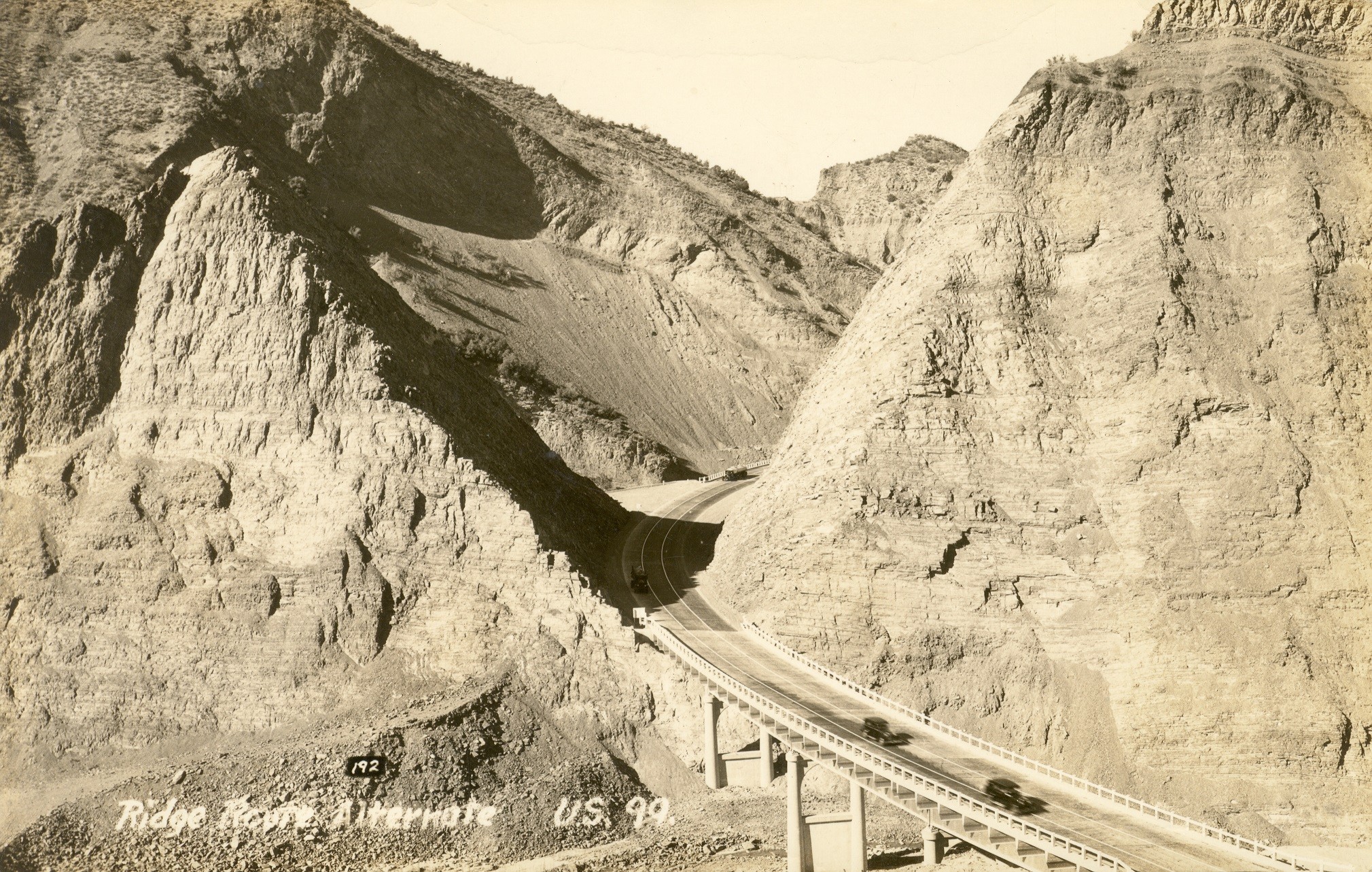
On October 29, 1933, four years to the day following the great stock market crash of 1929, the Ridge Route Alternate officially opened to traffic. This new road bypassed the treacherous 1915 Ridge Route by many miles, relegating it to a forgotten side-road. This also marked the opening of the largest realignment of US 99 in California. No other section was relocated as far from the original alignment. Today, the view shown in the postcard above is still possible, with one major change. Pyramid Rock and Cut remain, but a large dam is now directly behind it.
As we enter the summer season, vaccinations are increasing, and the pandemic seems to be subsiding, it is getting time to start working on getting out there more. We will be reaching out to more businesses, historical societies, and car clubs for events and presentations. We have been slowly building this Association and getting everything ready for a time when things are more open. That time is quickly approaching and we are ready to go! I look forward to meeting Highway 99 enthusiasts from all over and really putting this Association on the map.
We would also like to welcome our new At-Large board member, Chris Myers, from San Diego, California. Chris has a big interest in old highways, is looking forward to working on promoting Highway 99, and has helped us get our first article in newspaper in Calexico.
We do still need some help in designing things like hats, t-shirts, and brochures. We also need help at a local level in various parts of the state to help in our outreach programs as well as be our local ambassador.
Are you interested in writing an article for our newsletter? Contact us! We’d love to hear from you.
Advocacy / Projects
In May, we launched a new feature on our website we are calling “Highway 99 Adventures“. The highway passed through the heart of California and is still one of the primary roads to adventure. Our pages will show off some of the highlights along the route, such as the Old Ridge Route, the Cabazon Dinosaurs, and Shasta River Canyon. Learn about some of the now-famous restaurants that started right on Highway 99, such as In-n-Out Burger and A&W Root Beer. Visit places alive with geological wonders such as the Salton Sea, Mt Shasta, and the Sutter Buttes. Highway 99 is not only a Historic Route, but is a road to adventure. Take a trip over to our pages and discover some of what is waiting out there! Make sure to to tell them the Historic Highway 99 Association sent you!
On June 1 (Tonight!) at 6 pm PT, we will be hosting a Zoom presentation on the Lake Shasta area showing what the highway was like before the dam was built, what it took to move the roadway and railroad, and what remains of the highway when the lake gets low enough. Join us and learn!
Things are also opening up and we are working on getting more involved. In August, we are planning to attend the Pomona Swap Meet where we will sell t-shirts and other items to help raise funds, and increase awareness of Historic Highway 99. We are looking forward to meeting you there! It will be a good opportunity to meet some of the people that keep this organization going.
Other events are coming as well. We are looking at hosting an antique car show and possibly hosting some tours of sections of US 99 in Southern California. If you’d like to get involved, let us know!
Fundraising
As of May 31, we have raised $480 since our sign purchase in March. We have reached one of our primary short-term goals but there is a lot more work to do. We do still need your support. As we now have our 501(c)3, your donations may be tax-deductible. Any amount is welcome and helpful.
Are you a member of the Historic Highway 99 Association of California? You should be! Members-only events, such as presentations on the history of Highway 99 and benefits will be coming in the future. Joining the Historic Highway 99 Association of California is a great way to not only show your support for the roadway and its history, but to get involved and help our organization grow.
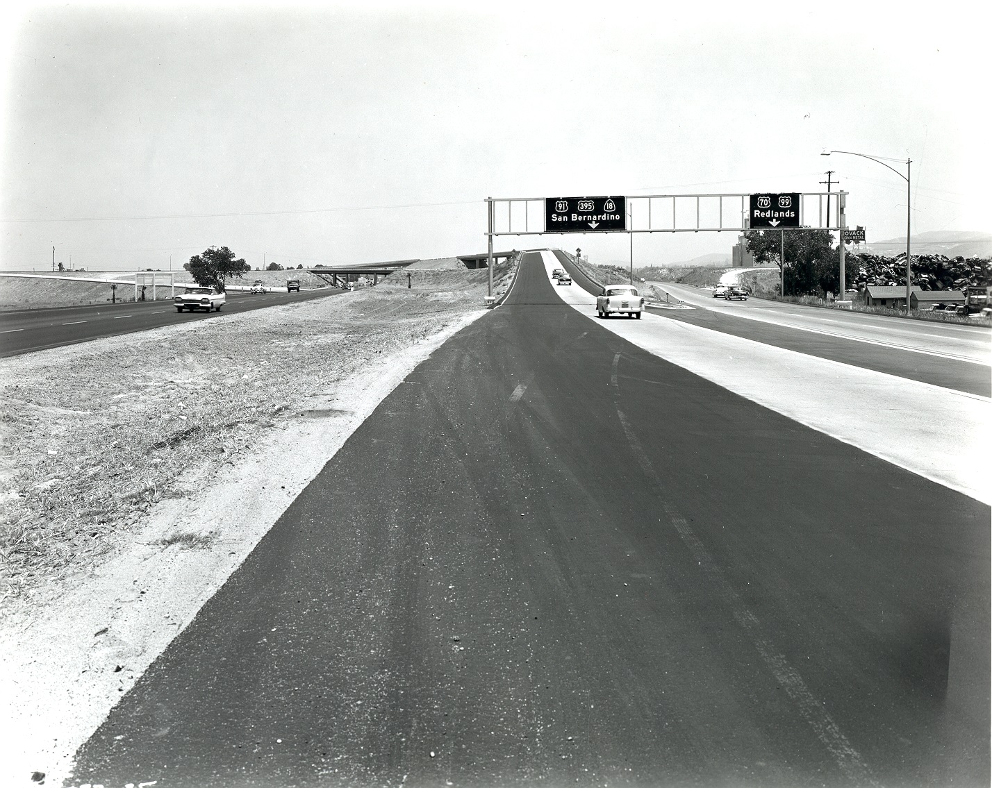
This month’s Featured Photo comes to us from Caltrans. What became known as the “Crossroads Interchange” started off as a small junction which eventually grew to be the massive I-10 / I-215 Interchange. In 1958, when this photo was taken, things were a little different. No Interstate routes had been signed yet. US 70, US 91, US 99, US 395, and State 18 all met here and went their different ways. US 99 would be removed in 1964 and the last US highway here, US 395, in 1969.