If you missed our presentation on May 17, you can view it on our YouTube channel at:
Additional prior meetings can be viewed at:
Historic Highway 99 Association of California
Dedicated to the preservation of California's Main Street – former US Highway 99
If you missed our presentation on May 17, you can view it on our YouTube channel at:
Additional prior meetings can be viewed at:
Our meeting and presentation on the Historic Ridge Route, originally scheduled for May 10, has been delayed one week and will be held on Tuesday, May 17, 2022 at 6 pm. I apologize for the delay and shift as I will be unable to attend on the original day. You may get a notice from Zoom if you have already registered. Thank you and I look forward to seeing you all there, one week delayed.
If you have not registered, please use the link below:
https://us06web.zoom.us/meeting/register/tZYvcuGsqzstGtJ2q0PNZ7FmvnNqAWeSNTKc
After gold was discovered in Coloma in 1848, thousands of people including Chinese arrived in California to seek work in the mining industry. Red Bluff was the furthest point north and the last ferry stop on the steamboat. The ferry stop would eventually create Pine Street with the first crossroad as High Street (currently known as Rio Street) and just one block further west would become Main Street or the old U.S, Route 99(W).

Logically, when the Chinese arrived in Red Bluff they took the boat as far north as possible in order to reach the “Gold Mountain” (金山 or “Gam Saan” in Cantonese). In China, they were told by the many companies soliciting laborers for work to “go abroad” so that one could strike it rich by finding gold in California and use their riches to improve their village, help fund educational institutions, obtain land expansion projects, etc. Since their early arrival in what is now known as Red Bluff’s Historic District, the Chinese were segregated to live on High Street beginning on Pine Street and ending on Hickory Street. The area on record was called “Chinatown”. What we know as Central Business Districts today, were former Chinatowns in most cities and former U.S. Route 99.
The truth is Chinatown was prosperous. It thrived because it was strategically located adjacent (one block south of Pine Street) to the railroad tracks where Sierra Flume and Lumber Company would fill carloads of logs into the Red Bluff railroad yard. The railroads offered a variety of jobs whether it was working on the expansion of the rail, seasonal farming jobs, rock walls or other season work.

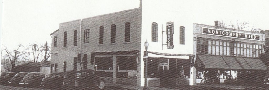
When the railroad was decommissioned, it became the old U.S. Route 99(E), but still adjacent to Chinatown. Although, Chinatown was located on High Street, it was just one block west of Main Street which meant it was close to U.S. Route 99(W). For the Chew family who originally came to Red Bluff in 1865-1870 (officially settled in 1888) the creation of U.S. Route 99(W) and 99(E) would create a smart business endeavor for them. So as the story goes, in 1949 the family (including children) pooled their savings together from the pinball machine at their first restaurant, California Café, and made a down payment on a larger property located at 860 Main Street and Hickory. It would become the popular restaurant, Ming Terrace. For the first time, the Chew family would serve Chinese American cuisines instead of American comfort food.

It would take another year of hard sweat and scrimping by to actually open the restaurant in 1949. Youngest siblings, Joe and Nettie Chew recalled that a friend, Harry On from Yreka, helped them buy a cash registered and later a car. The Red Bluff Daily News noted that “dishes of ancient China as well as American dishes will be served in a modern setting to progressive Red Bluff… The restaurant has paneled booths with chrome finish on tables and chairs, special embroidered painting imported from China and Ming trees made by Chinese craftsman in San Francisco.” Red Bluff Daily News circa August 30, 1949. Nettie and Julia Chew reminisce fondly that at the grand opening of Ming Terrace they wore their colorful Chinese “cheongsam” dresses to greet and welcome the customers to the new restaurant. With a new and larger business to develop, all members of the family worked long hours daily and then climbed upstairs from the restaurant to enter their living and sleeping quarters. Still common today in China, the alleyway was vibrant. In the rear of the restaurant, there was an alleyway which served as a
key corridor into Red Bluff’s Chinatown. So, the young children were tasked with gathering the chickens and the vegetables from the Chew garden, they would then bring them through the backdoor straight to the restaurant kitchen. What we call “Farm to Table”! The Chew family was well regarded mostly for their humility. During the Great Depression, eldest sibling, Dick Chew fed those hungry on an honor system. He just couldn’t bear to see folks go hungry. For the Ming Terrace, this tradition continued and if you were an out-of-towner stopping for gas, Chevron would send you to the Ming Terrace for a free “cup of Joe”! Business grew strong into the 1950s through the 1970’s.

However, the construction of I-5 to replace U.S. Route 99(E) and 99(W) would change everything. Joe was a naturally gifted man in finance and accounting even though he was the youngest sibling. He had the wisdom to realize that I5 would deter business away from Red Bluff’s Main Street hence, potentially becoming detrimental to the family business. Like many untold Chinatown stories, the construction of I5 would forever eliminate their once thriving neighborhoods ending the legacy of Red Bluff’s Chinatown in 1973 when the Ming Terrace closed. It was the last residence and business to operate in the long-lost historic Chinatown of Red Bluff, CA.
Although, a Chinatown no longer exists today, Red Bluff’s Chinese Pioneers now have descendants who have not only made America their home for generations but prospered due to the cross-pollination of ideas, ingenuity, contributions to science, healthcare, public service, business, and the arts, paving the way for the advancement of all Americans today. The newest transplants of Chinese families in Red Bluff have added to the town’s growth and diversity in numerous ways contributing to businesses and the labor market. In memory of the original Chinese Pioneers and in tribute to the honorable work of today’s Asian community in Red Bluff, the Helen and Joe Chew Foundation has submitted an application to name the alleyway adjacent to Main Street (where the old U.S. Route 99 once ran through), to “Historic Chinatown Alley”. We would like to thank you old U.S. Route 99 from the bottom of our hearts, you have made our Chinatown flourish and you are forever in our memories.
For further information, we strongly recommend heading to their website at Red Bluff Chew.

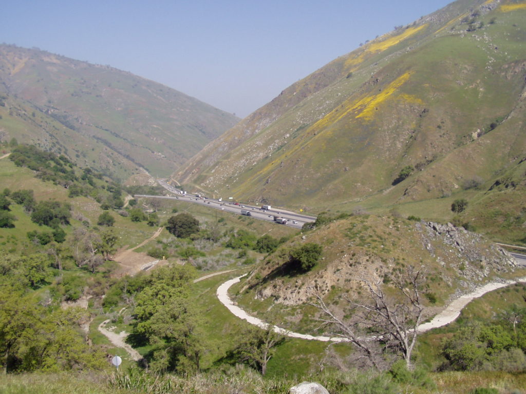
Join us on Tuesday, May 10, 2022 at 6 pm for a presentation via Zoom on the Historic Ridge Route by Michael F Ballard. The road will be covered from Castaic to Gorman. Learn about the current status of the roadway and the Ridge Route Preservation Organization that is working to reopen the roadway.
Please register for the presentation using the link below:
https://us06web.zoom.us/meeting/register/tZYvcuGsqzstGtJ2q0PNZ7FmvnNqAWeSNTKc
On the evening of Thursday, April 14, I gave a presentation on the history of US 99 through the San Gorgonio Pass to the San Gorgonio Pass Historical Society at the Cherry Valley Grange. This was the first time I had given a presentation in person in a very long time. To be honest, I was quite nervous but was confident it would go well in the long run. The event was well attended with a total of 68 people, far more than I had expected. It was also their second highest attendance. I want to thank the Historical Society and the attendees for allowing me the opportunity to give the presentation. I had a really great time and had a lot of fun.
As we slowly ramp up our efforts to get Historic Route signage placed in various cities and historic locations such as the Pine and Palm, we need your support. You can do this by becoming a member, donating money, or by volunteering with our Association. We are a 501(c)3 non-profit corporation and your donations may be tax deductible. Why not help reduce your tax burden for 2023 by donating prior? We can also use your help with some of our projects, website, and our newsletter. Having someone local to act as our ambassador or liaison would be of great help. We are also working out how to handle renewals for existing members. Initially, we had planned to have all memberships expire at a specific time. At this time, we are looking to have memberships expire at the end of the month initially obtained. Join now and help us grow!
We do wish to thank all those that have donated and become members thus far. Our most recent project in Madera couldn’t have happened without your support!

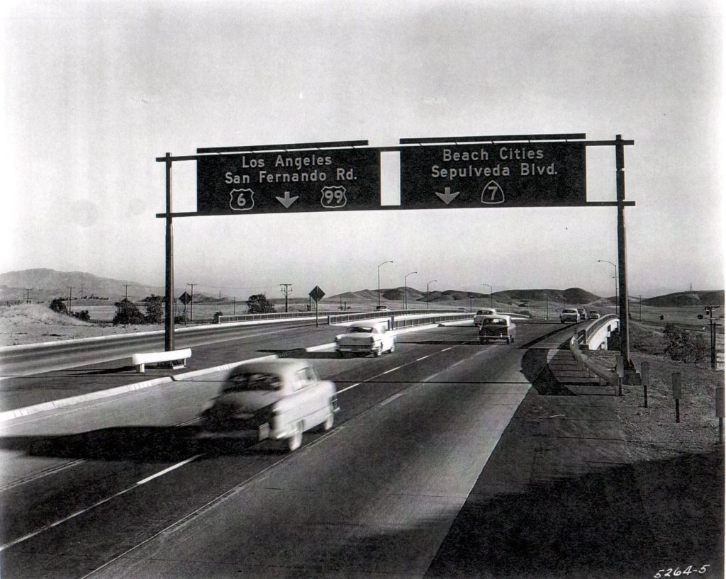
In 1955, the first section of the Golden State Freeway was completed in Newhall Pass. It stretched from Tunnel Station (Junction US 6) to Sepulveda Blvd (Junction State 7). Heading south into the San Fernando Valley, a choice had to be made. Follow US 6 / 99 to Los Angeles or go to the westside and follow Sepulveda Blvd. The photo above shows the split where it crosses over San Fernando Road (old US 99). You can also see how the striping was modified, likely to give more room and reduce the chance of someone cutting across three lanes to stay on 99. Today, this same split is a little further south, where I-5 and I-405 meet. The same choices are to be made today. Go to the city or go to the beach.

Join us on Tuesday, May 10, 2022 at 6 pm for a presentation on the Historic Ridge Route by Michael F Ballard. The road will be covered from Castaic to Gorman. Learn about the current status of the roadway and the Ridge Route Preservation Organization that is working to reopen the roadway.
Please register for the presentation using the link below:
https://us06web.zoom.us/meeting/register/tZYvcuGsqzstGtJ2q0PNZ7FmvnNqAWeSNTKc
On Thursday, April 14, 2022, I will be giving a presentation on the history of US 99 through the San Gorgonio Pass to the San Gorgonio Pass Historical Society. Their meeting will be held at the Cherry Valley Grange at 10478 Beaumont Ave, Beaumont, CA (corner of Cherry Valley Blvd and Beaumont Ave). Presentation starts at 7 pm and is open to all. Come join us!